
The Rising Tide Underfoot
Changing sea levels are pushing groundwater into new and problematic places.
Article body copy
Before dawn on July 3, 2018, staff at the Board of Water Supply (BWS) on the island of O‘ahu, Hawai‘i, received a slew of phone calls alerting them to water gushing across an intersection along Nimitz Highway, the major thoroughfare that connects the harborside downtown area of Honolulu to the city’s airport. A water main had split, and its contents were bursting to the surface.
Staff rushed to the site. Water-main breaks were not uncommon, but this site bore a specific risk. For much of the 20th century, this low-lying flatland was a main artery for channeling fuel from tankers in Honolulu Harbor through underground pipes to the rest of the island. Remnant pipelines and tanks now litter the subterranean landscape, and the toxic contents that once coursed through them have seeped into the ground, contaminating the earth.
When crews arrived at the spewing water main, the air reeked of fuel oil. The workers dug about two meters below the road. When they reached the 40-centimeter-wide cast-iron water main, it was submerged in water, and the pool was topped with a sheen of slithering fuel oil. Based on past experience, they knew the dirty water did not originate from inside the pipe—it was coming from the earth itself. Because at this site, around 100 meters from the Pacific Ocean, groundwater actually rises and falls beneath coastal roads and buildings according to tidal rhythms, picking up toxins from the soil as it moves.
Having the broken water main submerged in oily water meant danger. The contaminated groundwater could enter the line and taint the city’s potable water supply. Fixing the pipe would require precise choreography. The crew needed to wait for the groundwater level to drop at low tide and then rush to pump out the remaining pool of contaminated water to create a temporary dry repair zone surrounding the damaged water main. With its most nimble workers standing by, the BWS closed valves to prevent the pipe’s contents from flowing into the city and queued up as many tanks and tanker trucks for storage and transport of the filthy water as they had available. Contaminated water requires special disposal, so must be hauled away for treatment.
Once the workers started pumping, they had six hours to fix the water main before the tide pushed water back into the hole. They filled the first truck with oily water. It drove off to unload in a 75-cubic-meter steel storage tank, and the next truck started water uptake. It was an efficient, if anxiety inducing, syncing.
Fear swept through the team that they would run out of space in the tanks. In that case, they’d have no choice but to dump the contaminated water into the storm drains. It would flow into Honolulu Harbor, creating a catastrophic oil slick. Marine life would be devastated, the cleanup colossal. Environmental disaster loomed one misstep away.
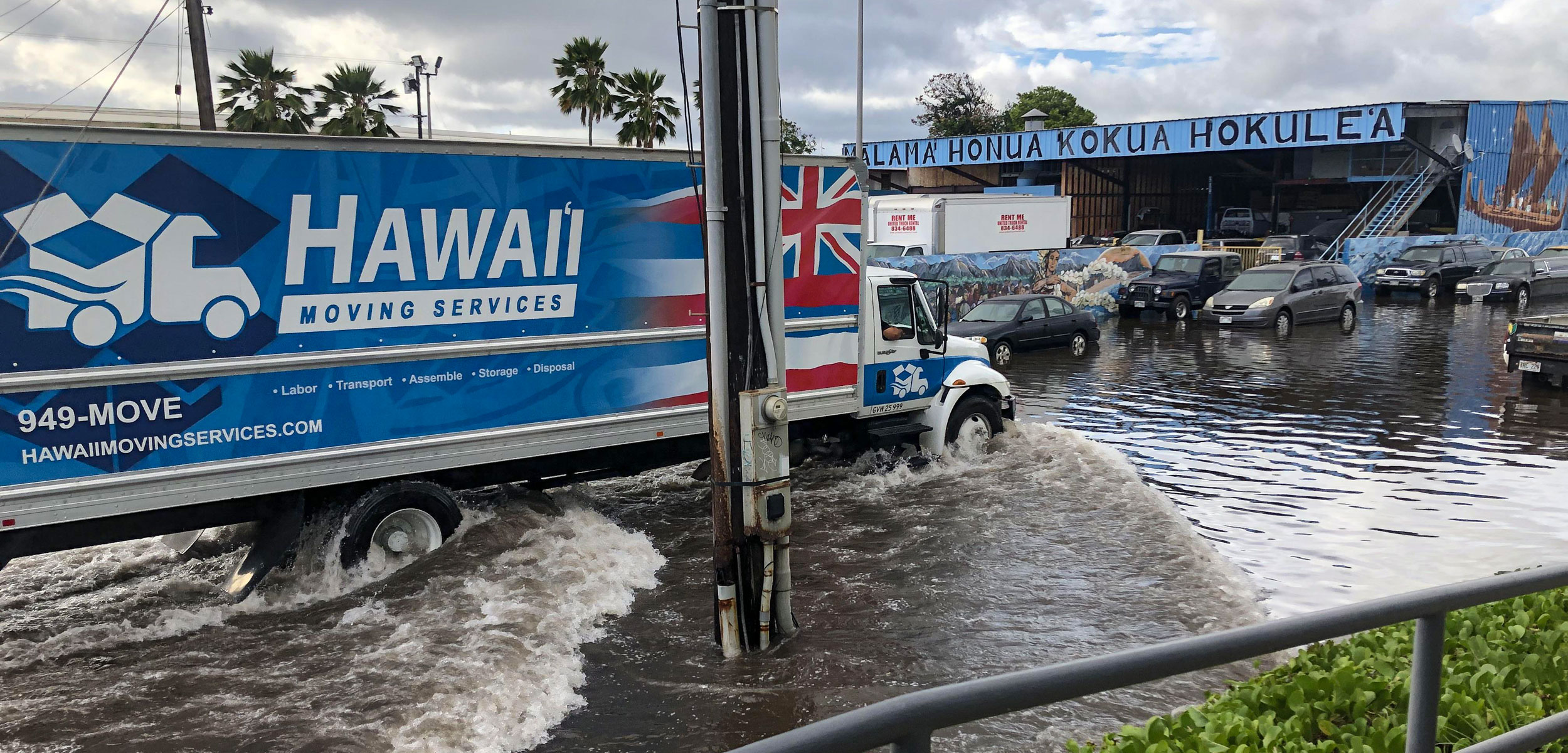
The Mapunapuna neighborhood is one of the first areas in Honolulu, on the Hawaiian island of O‘ahu, to experience increased flooding linked to sea level rise. Photo courtesy of Hawaii Sea Grant King Tides Project, 2019
Most conversations about rising sea levels focus on the direct impacts to coastlines—namely, erosion and marine flooding. But as ocean levels shift upward, there’s another less obvious impact: coastal groundwater is pushed upward, too. Groundwater is typically fresh water from precipitation that fills the small spaces between underground sand grains or rocks. In low-lying areas near the coast, it is often found less than a meter below ground, and, because it intermingles with seawater in those interstitial spaces, it is effectively connected to the ocean. The heavier salt water pushes up and mixes with the lighter groundwater.
The broken water main, likely corroded from the rising salty groundwater, was just the latest indicator that climate change is striking Honolulu—and urban coastal environments everywhere—in unanticipated ways. “Sea level rise does not look like the ocean coming at us,” says Dolan Eversole, the Waikīkī Beach management coordinator with the University of Hawai‘i Sea Grant College Program (Hawai‘i Sea Grant). “It looks like the groundwater coming up.”
Rising groundwater has the potential to debilitate many low-elevation coastal cities worldwide, particularly those constructed on loose material such as sand, gravel, or silt. In the United States alone, 3.7 million people inhabit land at risk of overland flooding linked to sea level rise, and even more will experience inundation once groundwater is taken into account. Even places slightly inland that most people think are immune to inundation could be affected. Buried contaminants may surface. Underground infrastructure—water and sewer pipes, as well as power, gas, and telecommunications lines—that was embedded in soil above the water table (the surface of the groundwater) will become soaked, and cast-iron pipes like the one along Nimitz Highway will corrode. Significant tracts of Honolulu face these risks, yet climate change and adaptation plans laid out by municipal and state governments only hint at addressing them.
Some of the first research linking sea level rise and the coastal water table came out of Honolulu. In 2011, then–graduate student Kolja Rotzoll was monitoring the water depths of wells for his dissertation at the University of Hawai‘i (UH) at Mānoa when he shared with university geologist Chip Fletcher that well-water depth fluctuated with daily tides and large offshore waves. Rotzoll’s data showed this connection in wells as far as five kilometers from the shore in areas that were flat. It struck Fletcher that mounting seas would similarly force the water table to rise. The two quickly published their deductions, which were subsequently harnessed by scientists around the country and world. Further studies indicated that metropolises from northern Europe to Southeast Asia, and in the United States along the Eastern Seaboard (New York; Washington, DC; Norfolk, Virginia; Miami, Florida) and the San Francisco Bay Area in California, could all be subject to the threats of rising groundwater.
In 2018, the crew was lucky to finish patching the water main along Nimitz Highway in time. They avoided environmental havoc, pumping out over 333,000 liters of fuel-contaminated groundwater. But there will be a next time. Barry Usagawa, of the BWS, says, “We expect that to happen more often, more frequently in the future,” referring to pipes breaking because of saltwater exposure.
In addition to infrastructural damage, Honolulu faces contamination risks that could have grave effects on human health. O‘ahu’s drinking water, tapped primarily from the island’s basalt aquifers, won’t be affected by rising groundwater, but if buried waste and the slick of fuel oil atop the water table taint water-supply pipelines, bacterial and viral infections could multiply, noxious fumes could off-gas in the city, and the potable water supply could be compromised. Property values could fall, and tourists, who have annually contributed upward of US $15-billion to Hawai‘i’s economy in recent years, would likely lose interest in the sodden paradise.
The coastal edges of O‘ahu were historically marshes and agricultural wetlands, situated above underground springs. When Westerners arrived in the late 18th century, they overturned the agricultural practices of the native Hawaiians who had taken advantage of the area’s fluctuating water levels, raising fish along the shore and growing crops like taro in flooded fields bordering the ocean. By the mid-1800s, the Hawaiian government, in part encouraged by American trade interests, started dredging what is now Honolulu Harbor, facilitating easy passage of trans-Pacific deepwater sailing vessels. The dredged sediment was dumped in the tidelands and the nearshore area, forming new land just high enough to not flood. Today, this fill undergirds significant tracts of Honolulu’s urban fabric, and areas built on the dredged fill are especially at risk of rising groundwater.
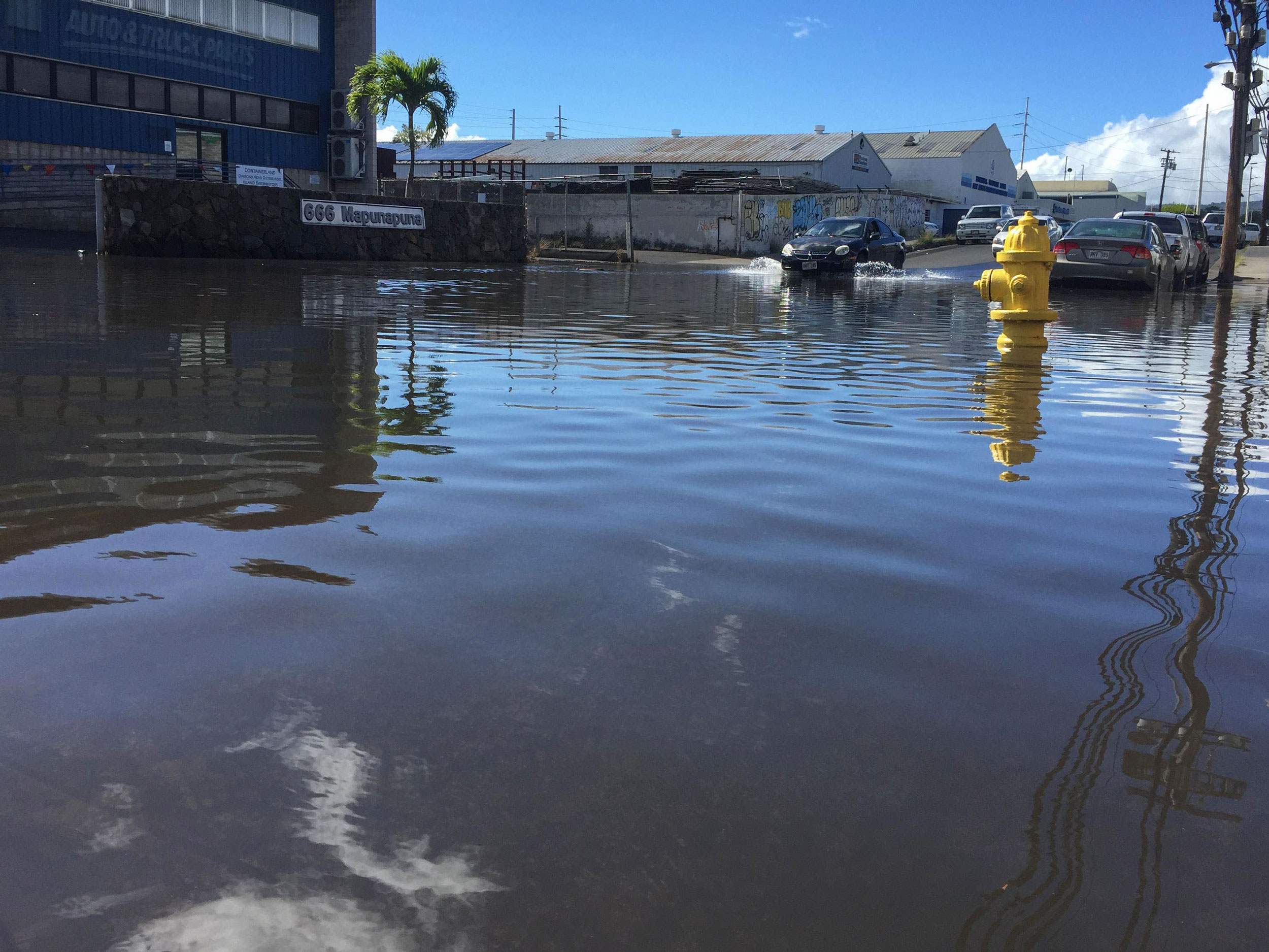
As the already high groundwater levels of Honolulu rise, the earth will have less capacity to absorb heavy precipitation, and many of these areas will flood during intense rainfall or during high tides, if they haven’t already. Eventually, some areas will be permanently underwater. The industrial neighborhood of Mapunapuna, located near the airport and built on subsiding filled-in marshland, is among the first to confront increased groundwater flooding.
Shellie Habel, a coastal geologist with Hawai‘i Sea Grant who has been at the forefront of groundwater research in the state, suggests we visit the area. As a former graduate student in Fletcher’s lab at UH Mānoa, Habel worked in recent years to expand and refine Fletcher and Rotzoll’s earlier sea-level-rise flood projections. The team’s projections indicate that nearly all areas impacted by marine flooding will also be affected by groundwater flooding.
It is March 2019 and the streets are mostly dry as we amble down the broken, undulating sidewalk, but Habel nonetheless identifies seemingly benign clues of the mounting groundwater beneath us: corroded manhole covers, rusted in place; cavernous splits in the street; salt from evaporated seawater accumulating at the road’s edges; a drainage culvert filled with salt water and live saltwater fish. Given that the ocean isn’t in sight, these signs of seawater are troubling.
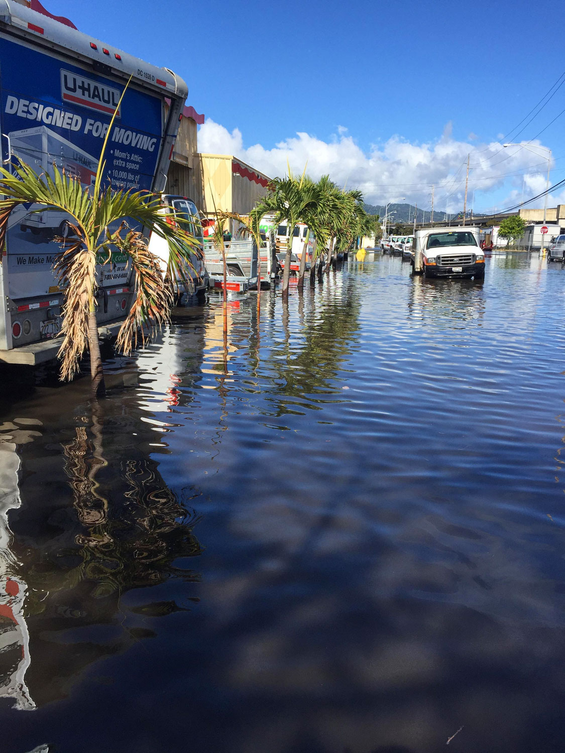
In 2017, access to the Mapunapuna U-Haul facility became problematic when the street and parking lot flooded. Photo courtesy of Hawaii Sea Grant King Tides Project, 2019
In recent years, the high tides in Mapunapuna have been intensifying, exacerbated by rising sea levels. The fish-filled culvert drains directly into the ocean, and at high tide, the ocean ebbs right back into the culvert—often overflowing into the street. It could seem that the ocean is merely channeling through the storm drains, but the surfacing water tests positive for radon, which is naturally present in the basalt rock underground—evidence that the sea is shoving up (and mixing with) the freshwater lens of groundwater.
Summer, which sees some of the highest tides of the year, is particularly taxing for local businesses. At a U-Haul facility, manager Rod Doronio describes how, in advance of the high tides, he and his staff wedge plastic thresholds in front of doors to prevent water-transported debris from streaming inside. They’ve lost significant income because customers can’t reach them. “It’s made things very difficult for everybody in this community,” he says. Two months before we meet, his car was mangled after plunging into an approximately half-meter-wide sinkhole and crater that occupied half the street in front of his shop.
Because of topography, Waikīkī, the densely developed, hotel-strung beachfront tourist district located about 10 kilometers southeast of Mapunapuna, isn’t yet experiencing groundwater flooding of this magnitude, but Habel says it will within a couple of decades. The Hawai‘i Sea Level Rise Viewer, an evolving online mapping tool built off data supplied by Fletcher, Habel, and other researchers, visualizes future flooding predictions, factoring in both rising groundwater and encroaching seas along the coast. Blue swaths increasingly creep through the streets of Waikīkī at 30, 60, and 100 centimeters of sea level rise above current levels, the last of which could happen as early as 2100. It’s a wake-up call for those who considered themselves a safe distance from Waikīkī’s eroding shoreline and increasingly higher waves. The Trump International Hotel located a couple of streets inland, for example, is situated in the middle of one of the map’s blue knots that starts to form at 60 centimeters of sea level rise. By 100 centimeters, the hotel becomes surrounded by a veritable canal, the water inundating the streets and likely impairing the hotel’s ground-level infrastructure. Another set of maps on the viewer describes potential economic loss: 15 centimeters reveals losses in the tens of millions of dollars; by 100 centimeters, the sum balloons to hundreds of millions. That sum doesn’t even include the costly repairs and adaptation of roads, airports, and other infrastructure, or of Hawai‘i’s valuable beaches.
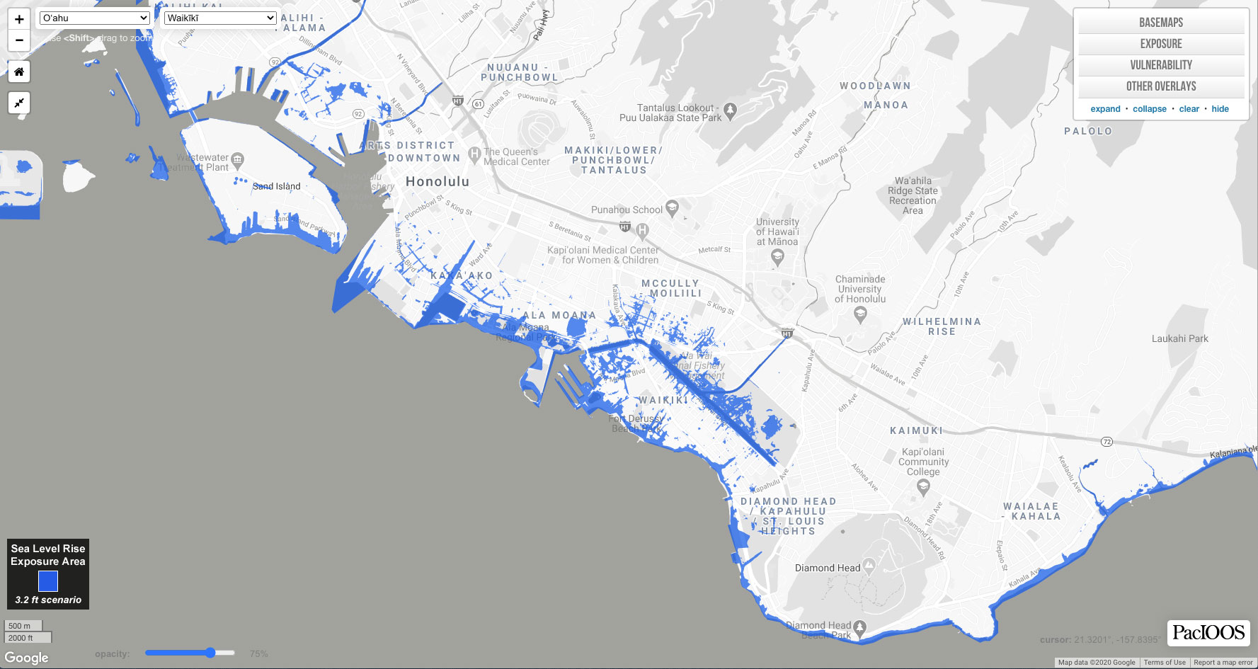
The Hawaiʻi Sea Level Rise Viewer shows the combined impacts of rising seas and higher groundwater. Map by PacIOOS/NOAA
Flooding of homes and businesses may cause the most commotion, but the effects of rising groundwater on underground infrastructure in Honolulu are often more far-reaching and costly. A recent study by the BWS and the Water Research Foundation based out of Denver, Colorado, identified that approximately 35 kilometers of water pipelines along the coast (like the one that broke in July 2018) would be impacted by 100 centimeters of sea level rise, the cast-iron pipes aging faster, corroding, and ultimately breaking due to saltwater contact.
Another discrete risk posed by groundwater relates to Honolulu’s wastewater treatment systems. Waste disposed to cesspools, an outmoded method of sewage disposal whereby waste is spat directly into the ground rather than treated, could surface with rising groundwater. Hawai‘i has more cesspools than any other state, and O‘ahu alone has more than 11,000—of these, 240 are in Honolulu’s wealthy Diamond Head neighborhood, demonstrating the problem is both urban and rural. Hawai‘i has stipulated that all cesspools must be replaced and connected to sewer lines by 2050, though that may not be soon enough to avoid contamination risks.
One threat posed by rising groundwater that receives little attention is its ability to dislocate industrial contaminants. Just like the area around Nimitz Highway, the ground beneath Honolulu is riddled with decommissioned storage tanks that still hold petroleum or other toxic contents. Any time a leak from one of the tanks is detected, the Hawai‘i State Department of Health installs a monitoring well—Honolulu has hundreds. Habel used the wells to gather data for her groundwater model. “When you put [a sensor] down the well to monitor and bring it back up, the rope is always totally covered in this goo,” Habel says. All of that goo—from fuel oil to heavy metals—could emerge with the groundwater.
Besides petroleum, which is generally seen or smelled, other contaminants in Honolulu’s coastal industrial zone are invisible and odorless, like metals (for instance, arsenic from pesticides or lead from incinerator ash and lead-based paint) and solvents. Some contaminants are permitted to stay in place if the site’s future use remains industrial or commercial. This is especially true in Hawai‘i, where, as an island chain, landfill space is finite, remediation options are limited, and shipping contaminants to the mainland is expensive and impractical. Yet, explains Lynn Bailey of Hawai‘i’s Hazard Evaluation and Emergency Response (HEER) office, to her knowledge, there hasn’t been a study to see which contaminants will be the most concerning as groundwater levels change, or how they might move through the environment. “Some contaminants may be entrapped in soil pores, some may rise to the surface, some may move inland or out to sea,” Bailey explains over email. Many people don’t know that the landscape remains contaminated even after remediation, and fewer understand the potential risks, she says. “Lack of public knowledge,” Bailey says, “is at this point one of the most critical things.” Once the public learns, they can start pushing for solutions.
The ways we should respond to rising groundwater are not obvious. Conventional protections like sea walls and levees are ineffective. In Mapunapuna, valves were installed on storm drains in 2011 so precipitation can flow in, but seawater inside the drains cannot flow out. But, says Usagawa, “You cannot put a backflow device on it if it’s coming out of the ground.” In the long run, it’s likely that Mapunapuna will be allowed to flood, its businesses relocating.
At Bailey’s HEER office, teams are starting to discuss how rising seas will affect their environmental site evaluations “on a site by site instance when we can,” though cannot yet articulate what form mitigation measures will take.
At the BWS, Usagawa speaks to the urgent need to create adaptation plans for sea level and groundwater rise that encompass all infrastructure, including systems of potable water, sewage, drainage, transportation, power, and telecommunications. “We [need] a clear plan on where we’re gonna lift, how high we’re gonna lift, what studies do we need to figure that out, how we’re gonna get financing, what kind of regulations we need to put in place, how you get the funding,” explains Usagawa. O‘ahu’s leaders are developing resiliency and adaptation plans for the island, yet so far there’s been little concrete action on the ground. If the leaders wait much longer, some places will be inaccessible. Usagawa wonders, “Once the beaches start to disappear—Waikīkī Beach will be inundated—will the tourists still come?”
Lifting roads and infrastructure can protect some of the systems, at least temporarily, but won’t solve all problems. Tim Houghton, deputy director of Honolulu’s Department of Environmental Services, explains that most wastewater systems rely on gravity and gravity-driven wastewater pipes that can’t simply be raised, because they won’t function. “The concern that I don’t know we have an answer for yet,” he says, “is how do you relocate an entire set of systems that is all gravity based.”
Mitigating the impacts on buildings will be another major hurdle. At present, about a dozen Waikīkī properties—mostly hotels and commercial buildings—already experience nuisance flooding once or twice a month. Eversole advises them to deploy pumps and relocate underground electrical and emergency generator systems from the ground level. Currently, no building regulations or construction codes are in place to address sea level or groundwater rise and, of most developers, Eversole says, “It’s not clear to me that they’ve taken any precautions for sea level rise.”
But the recent scale of flooding during big tides, exacerbated by groundwater flooding in unexpected places, has begun to convince many of the coming reality. Locals will eventually start asking what’s going to be done about it. And, says Usagawa, “We better have a plan in place.”