
Coast Today, Toast Tomorrow
Slumping shorelines, roving rivers, and exploding islands—five coastlines that I’m sure were here yesterday.
Article body copy
As sure as waves hitting a beach, coastlines are subjected to subtle changes. Sand shifts with each wave, tides ebb and flow, dunes grow and recede throughout the year. But sometimes, the change is catastrophic and forever alters the coastline and the communities living on it.
Swept Away
On December 26, 2004, in Aceh province, Sumatra, tourists and locals enjoying the beach were fascinated when the water suddenly receded, revealing parts of the sea floor that they had never seen. But this was the first sign of the oncoming tsunami, caused by a magnitude 9.15 earthquake off the coast of Indonesia. The water roared back to shore, killing more than 200,000 and leaving devastation and an unrecognizable shoreline in its wake. In Aceh, huge swaths of the coastline dropped dramatically, allowing seawater to surge inland where it filled waterways and destroyed bridges. The coasts of nearby islands rose as much as two meters. Today, the coast may look dramatically different, but locals in Aceh are well into their recovery process and are living much as they did before the disaster. In the decade since the tsunami, survivors have rebuilt, and tourists are returning.
Wearing Down
Since 1996, citizens of the coastal hamlet of Newtok, Alaska, have worked toward a difficult decision: most of the approximately 350 townspeople voted to abandon their homes and relocate to a new settlement about 14 kilometers to the south. The reason, in short, is global warming. The sea ice that used to protect the Alaskan coast from violent waves is melting rapidly. As a result, the town is losing meters of shoreline each year as erosion and rising water levels eat away the coast. But Newtok is just one of about 200 Alaskan settlements that are affected by erosion and flooding. Towns such as Kivalina and Shishmaref are having similar conversations, and 11 communities at immediate risk are exploring options to relocate part or all of their towns to safer areas. Despite difficulties in gaining funding and both logistical and political challenges, the residents of Newtok are desperate to relocate—the US Army Corps of Engineers estimates that the town’s school and some homes may be underwater by as early as 2017.
Stormy Weather
Visitors to the town of New Romney, about a kilometer from England’s southeast coast, find a quaint village at the edge of a marsh with a 12th-century church at its center. Upon inspection, however, elements of the church seem out of place—why would a church have boat hooks, or an entrance below the ground, or an exterior covered with numerous scratches, stains, and gouges? The answer lies in one violent event in New Romney’s history. Anyone who came to the town before the year 1287 would have seen a completely different place—a port town nestled between the River Rother and the English Channel. Then, in 1287, everything changed when a huge storm hit the area. Several nearby settlements were damaged by the tempest (one was totally destroyed), and New Romney was almost destroyed, too—the storm deposited so much earth in the local waterway that it changed the course of the river, which now flows through the town of Rye, 15 kilometers to the west. The church was one of the few buildings left standing in the now-landlocked town, and it still has the scars to prove it.
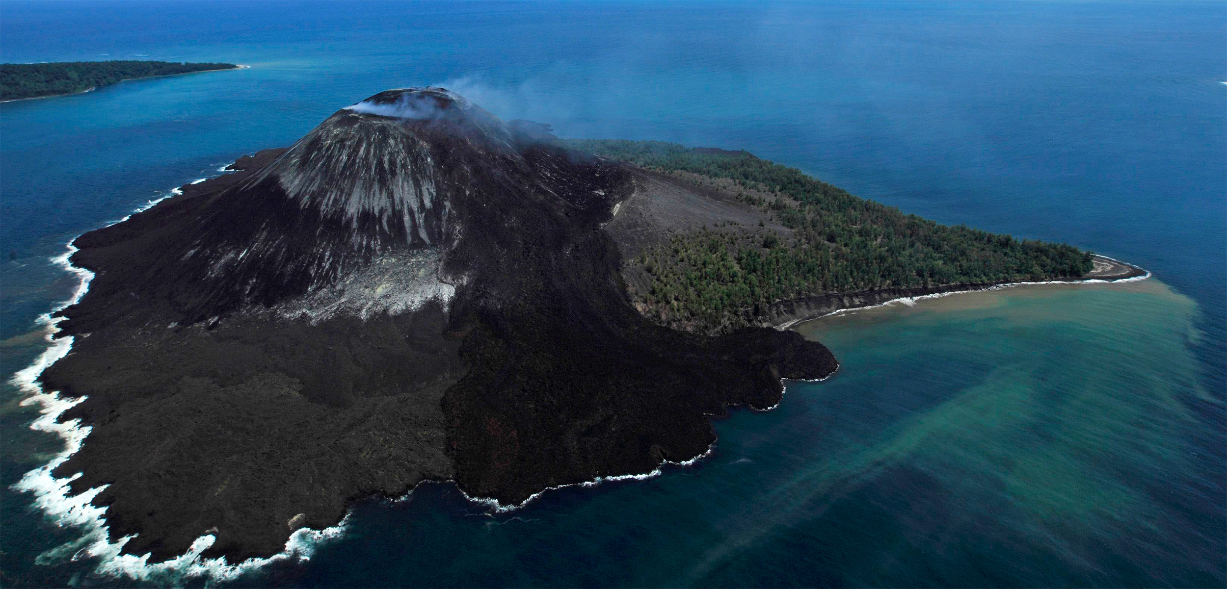
Out With a Bang
Most days, the tiny island of Krakatau (or Krakatoa) appears peaceful, with its black sand beaches and lush forests. But throughout its history, volcanic Krakatau has been anything but placid. Over the past 2,000 years, dozens of eruptions have built and destroyed the island, and brought tsunamis and planet-wide changes to weather. Krakatau’s most famous outburst roared across the modern world on August 27, 1883, when it exploded in one of the most powerful eruptions ever recorded. The series of blasts shot gas and debris into the air with the force of more than 10,000 Hiroshima atomic bombs, killing at least 36,000 in the process, mostly due to the resulting tsunami. When it was over, the entire island was unrecognizable. Seawater had filled the volcano’s magma chamber, and its massive cone was barren rubble. Just 44 years after the eruption, some fishermen saw steam and debris rising from the sea—a year later, a new island started to rise where Krakatau once stood. They named it Anak Krakatau, the child of Krakatau, and, as lava intermittently erupts from its caldera, the island still grows today.
Lost Paradise
Though much of Haiti’s well-known poverty is due to its troubled history, disasters caused by its geography—earthquakes and subsequent tsunamis or landslides, and flooding from tropical storms, compounded by centuries of deforestation—haven’t been much help. But the people are resilient. In the seaside village of Petit Paradis (“Little Paradise”), about 45 kilometers southwest of Port-au-Prince, life seems little changed, even though a magnitude 7 earthquake ravaged the island just six years ago. Since 2010, the villagers have been rebuilding their homes and fishermen have returned to the sea. And yet, some changes have been more enduring. A solitary tree that juts out of the water 70 meters from the village once stood on the beach. An earthquake and underwater landslide permanently moved the coastline, and the lone tree surrounded by the sea is a lasting reminder of the ever-present potential for shorelines to shift.