
A Visit with the Glacier Squad
For 35 years, a scientist and his team have been taking the pulse of 10 coastal glaciers. The diagnosis is in.
Article body copy
Walking the icy flanks of Mount Baker—an active volcano in Washington State and one of the highest peaks in the Cascade Range—is probably one of the most untainted wilderness experiences. And yet, it feels profoundly unnatural to me as I trudge up an oblique sheet of ice with crampons lashed to my boots and an ice axe hefty enough to clobber a mountain goat or a yeti gripped tightly in one hand. When I stop to fumble with my backpack and readjust my borrowed, baggy rain pants, which are failing to keep moisture from penetrating the innermost layers of my clothing, Mauri Pelto, the glaciologist who has brought me here, offers me a reprieve. “As we head into this icefall, you have to let me know,” he says quietly. “Maybe it’s just not the place for you.”
I have been asking myself this—whether this field of ice, known as the Easton Glacier, is the place for me—since the evening before, when I tried to navigate what Pelto had described as an easy jaunt to his camp more than a kilometer up a stream channel only to find myself stumbling across an obstacle course of mud, boulders, dense clusters of alder saplings, and glacial till. When I finally located his crew’s two tents well after nightfall (which, on an early August evening, arrived just before 9:00 p.m.), Pelto called out casually from inside one of them without disengaging from his sleeping bag: “Welcome to camp.” Then this morning, when we set out in the rain and I saw the glowing blue and gray leviathan of the Easton Glacier looming through the clouds, doubts churned in my stomach.
A high mountain glacier, in its frigid, deadly enormity, doesn’t feel much like a landscape meant for humans. In the European Alps, medieval myths held that glaciers carried curses and incarcerated the frozen souls of the damned. And yet, on a grand scale, where glaciers and humans coexist, our lives are entwined in ways we rarely realize. During the last ice age, the glaciers of Alaska locked up so much water that the seas lowered enough to create a land bridge to Siberia and perhaps allowed the earliest passage of humans into North America. Glaciers have carved out many of our mountain ranges, scoured out plains and prairies, and birthed rivers and lakes. Today, in many parts of the world, mountain glaciers preside over vast empires of fresh water that reach from the highest peaks to the coast: they dictate the flow of water downslope and influence the seasonal pulse of rivers and fish and the temperature and chemistry of streams and estuaries. They supply water for drinking, irrigation, and hydropower dams. But as the world gets warmer, glaciers’ influence in many regions is waning.
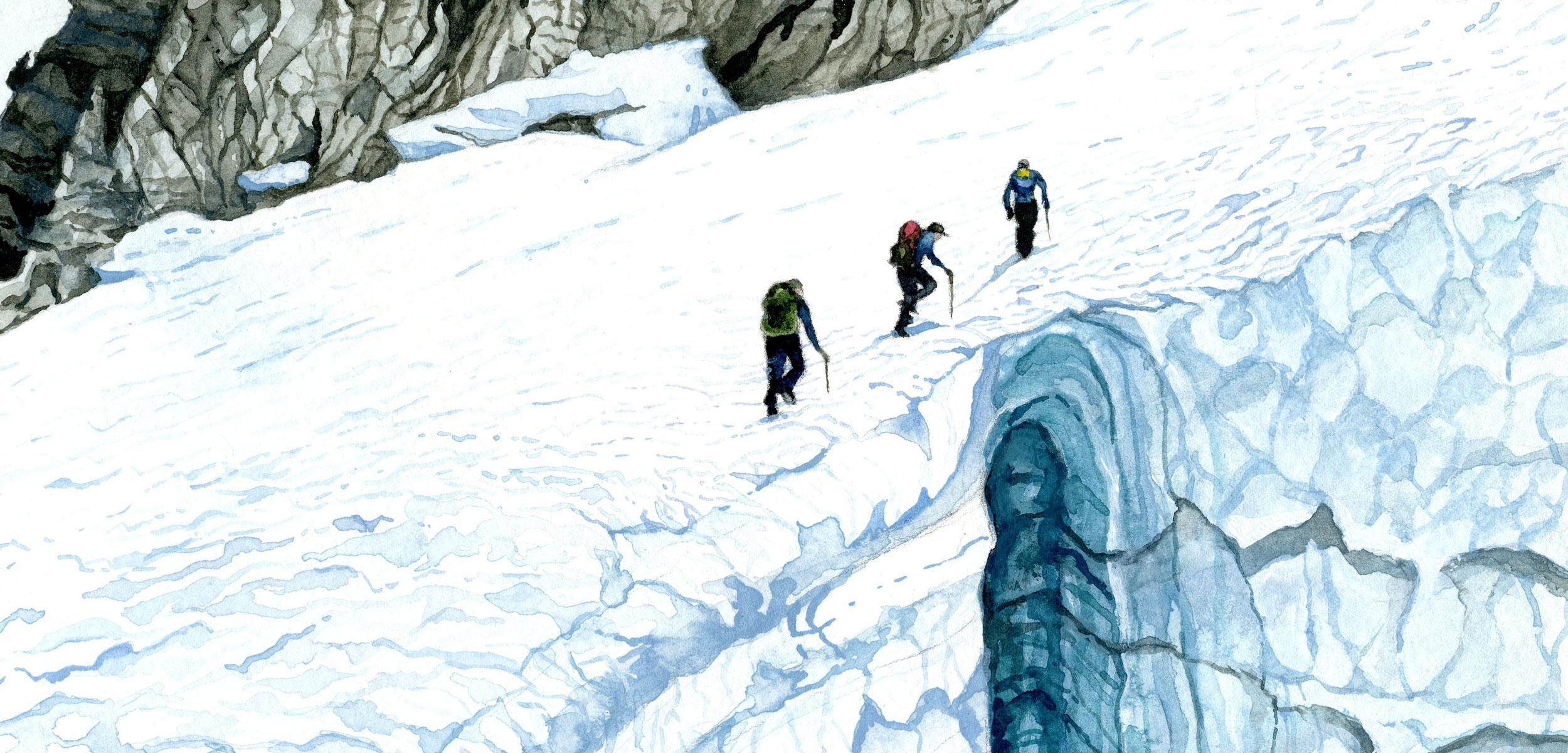
Pelto, a professor at Nichols College in Massachusetts, has been traveling to the northwest United States to document the behavior of glaciers every year for the past 35 years, witnessing their decline and fall, and this is why he regards the otherworldly scene before us with a kind of nonchalance. All morning, he has pointed out where the glacier used to be—in the 1990s, an area presently marked by the bit of precocious vegetation that has begun to colonize; then the early 2000s, a space now mostly comprised of bare rock and mud; then 2009, when his daughter, Jill, first came here with him as a teenager. She strides cheerfully behind him now, along with two graduate students from Maine—Mariama Dryak and Erin McConnell. Both are similarly sanguine, even though McConnell is wearing crampons that barely fit her boots, tied on precariously with some extra straps repurposed from her backpack. Through wind and rain, we have ascended a slope covered in glassy ice so hard we have had to stomp the crampons in just to get a foothold. Still, the women are unflappable and curious, lobbing questions at Pelto and at each other, and noticing formations and debris in the ice—from the geological bands left by meltstreams to a bit of tire tread and some pistachio shells presumably deposited months ago by incautious snowmobilers.
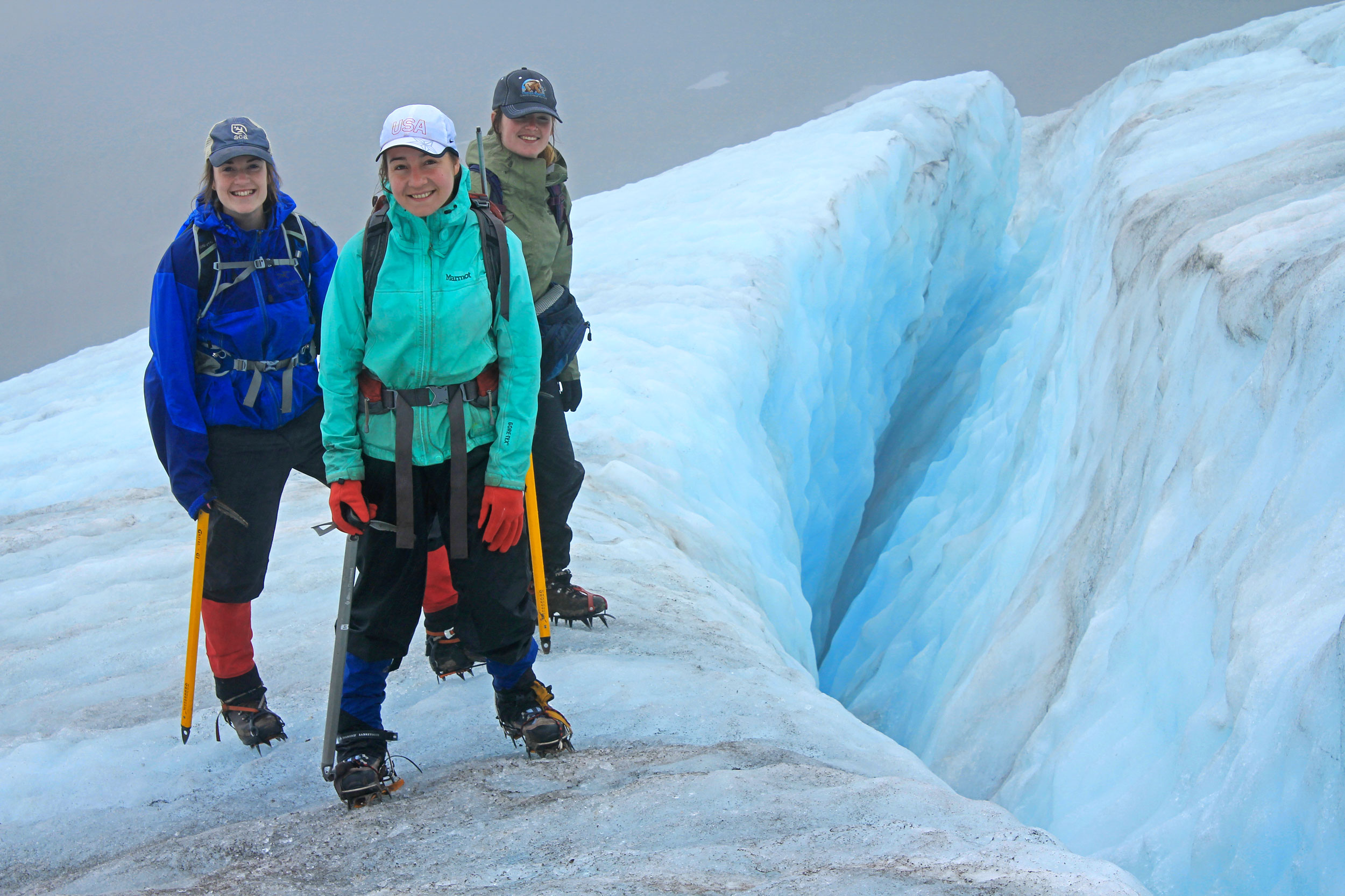
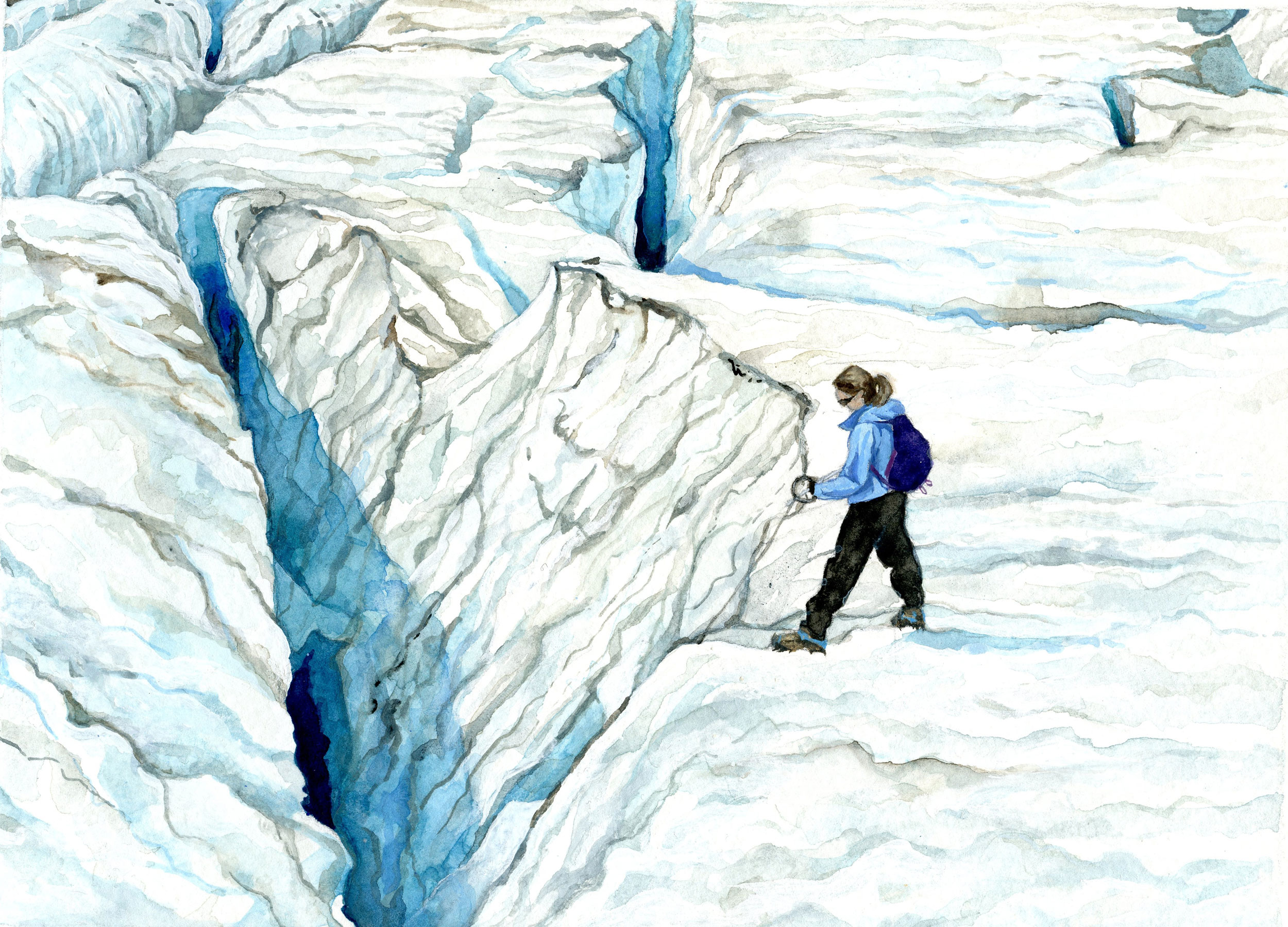
For scientists ascending the Easton Glacier in the Cascade Range of Washington State, it takes proper equipment and a sense of adventure. From left: Mariama Dryak, Erin McConnell, and Jill Pelto. Photo by Madeline Ostrander
Ahead of us lies the icefall. Despite similar etymological origins, this unearthly terrain looks no more like a waterfall than a lunar crater resembles a river gulch. The icefall is instead a steep landscape of toothy crevasses gaping through 10 meters or more of ice thickness. I forge on, gasping and crunching across granular ice pebbles that look like glass fragments, lagging behind the others. I am quite certain that I don’t belong here, but I am too stubborn to turn back.
To the First Peoples of northwest North America, the high realm of glaciers held spiritual significance. One might visit such a place seeking knowledge or guidance. “Places uncontaminated by other humans are where you found the strongest spiritual help,” recalled the late Vi Hilbert, an elder of the Upper Skagit Indian Tribe, in a 1996 interview.
But when Pelto began his work in the North Cascades—the upper section of the spine of mountains that stretches from Northern California to British Columbia—glaciers weren’t getting much scientific attention. His own obsession with them grew from his love of snow. Pelto was an avid winter athlete and considered trying out for the US Ski Team in 1983, after finishing his studies at Michigan Technological University. But two years previously, he had joined a research trip to the Taku Glacier in southeast Alaska. He was drawn to the massive icy body, fascinated by how dynamic it seemed to be—moving, pulsing, circulating air and water, almost like a living creature. And as he considered his career options, he realized he could always keep skiing. But if he wanted to spend more time in the company of glaciers, he would need to study science.
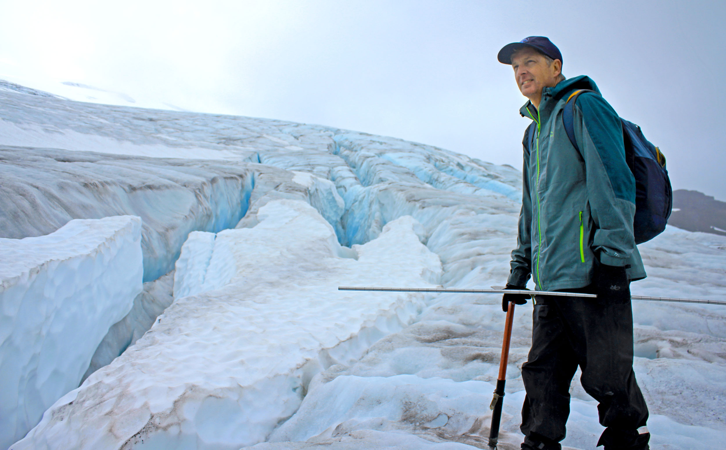
Glaciologist Mauri Pelto, hiking the Easton Glacier. Photo by Madeline Ostrander
At the time, glaciology was an obscure scientific niche, and you could probably gather up all its experts and adherents from around the world and fit them into a single lecture hall. In 1983, he attended a meeting of the International Glaciological Society at Northwestern University outside Chicago. The gathering held a sense of urgency: glaciers were entering a period of trouble, upheaval, and loss that would likely affect their well-being for centuries if not millennia. Their role in the world could rapidly diminish as global warming robbed them of size and vitality. There was much about glaciers that the scientists wanted to account for, measure, study, and understand before the ice began to transform dramatically. The US Geological Survey (USGS) had collected some long-term glacier data, starting in 1958 with the South Cascade Glacier, about 130 kilometers northeast of Seattle, Washington. In 1964, UNESCO called for countries to conduct global research on water, and in response, Canada began an inventory of its glaciers and set up long-term monitoring projects at the Place Glacier (140 kilometers north of Vancouver, British Columbia) and the Peyto Glacier in Banff National Park in the Rockies and a number of other shorter-term glacier studies. But the approach on both sides of the border was piecemeal. By the 1980s, the USGS only kept tabs on about one glacier per major mountain range. In the United States, the National Academy of Sciences called on researchers to follow multiple glaciers in a single mountain range. But the Reagan administration was cutting budgets for a number of scientific and environmental agencies, the USGS included, and it seemed hard to imagine who would be able to follow such a recommendation.
Pelto—though still in his early 20s and then a novice at conducting science in the field—figured he could be the one. He enrolled in a graduate program at the University of Maine, but he wanted to study a place where glaciers lived in close proximity to people. So he chose as his research subject the North Cascades—even though they lay on the opposite end of the continent—because they held sway over the lives of at least several million people in their domain.
He developed a 50-year plan that would carry him all the way to a late retirement. He visited 120 glaciers in the Cascade Range and chose 10 that would receive an annual, in-person checkup. About 40 others would receive a visit at least once every five years, and he would follow them remotely via aerial photography and, from the 1980s onward, satellite imagery. At the beginning, he recruited long-time mountaineers to serve on his field crews—mostly men who’d been climbing since the 1940s, including some famous characters like Bill Prater, who, with his brother Gene, invented the modern metal snowshoe to replace the old, impractical wood-and-bamboo variety. (The Easton is the launch point for one of the main climbing routes up Mount Baker, and many mountaineers have traversed it.) He collected the mountaineers’ photographs and stories, and then began to build up his own record. “It’s not just the data set,” he says. “You spend a long enough time working on anything … you develop an innate sense of what is impacting [it].”
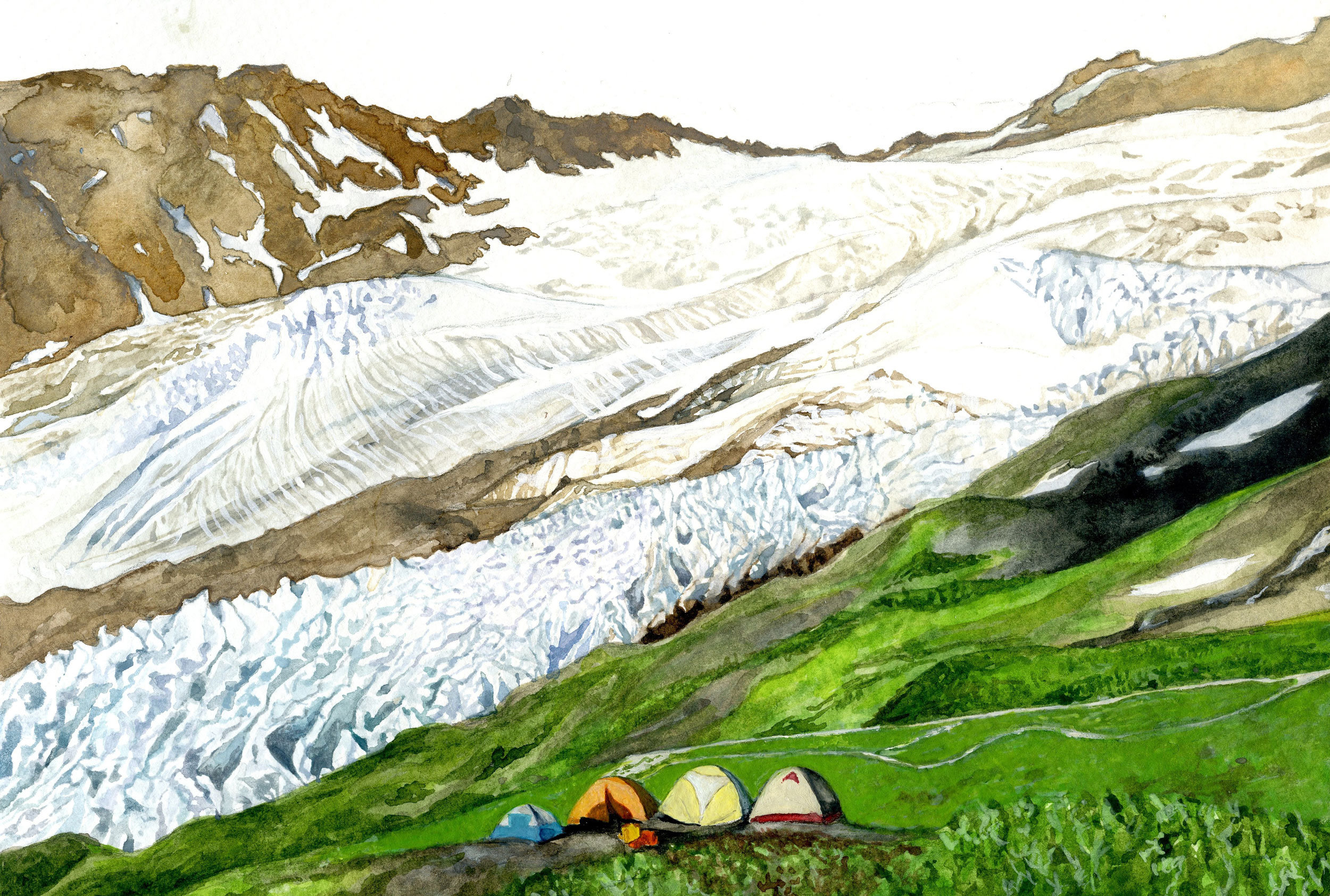
The scientific team’s camp has moved along with the glaciers that are receding as the climate changes. Illustration by Jill Pelto
In the 1980s, the USGS thought glaciers might behave differently under warmer conditions based on the microclimates around them. But Pelto soon realized glaciers were responding in unison to climate change. “They’re all suffering,” he says.
Three decades later, the idea that glaciers are vanishing, that they are harbingers of climate change, is now well known. Six of the 120 Cascade glaciers Pelto originally surveyed have perished, including four of those he surveys by satellite imagery and two of the 10 he chose for his initial field study (which he’s since replaced with two glaciers that are still alive). When the regime of glaciers fully comes to a close—when rain and sun dominate over ice and snow—this will spell trouble for the rivers and coasts below. Few people have yet reckoned with the consequences.
If you have only ever glimpsed a glacier from afar, it would be easy to think of it as a large but inert smear of snow. Three years ago, I gazed at the Exit Glacier in Seward, Alaska, from a partially paved trail—an experience akin to seeing a polar bear at the zoo, so well-contained that it lost all sense of wildness or danger. So I had not imagined how ferocious the Easton would feel—angular, massive, thrumming with meltwater. We begin the day at about 1,700 meters elevation, and Pelto says we’ll stop at about 2,000 meters. But the glacier rises well above this for another 800 meters. In total, the Easton stretches about four kilometers in length and three square kilometers in area, or roughly the size of 160 Manhattan city blocks. The terrain has a primordial quality, accentuated by the pale cyan light that emanates from the ice surface. The oldest ice dates to Mount Baker’s last eruption about 6,700 years ago.
We encounter a few other creatures on the ice. They appear suddenly, like apparitions. Grosbeaks flit past us. I spot a frozen green fly of unknown origin. (Jill tells me wind can carry insects long distances up the mountain, and spiders can find themselves accidentally airborne over a glacier, propelled upward by the electrical charge differential between the ground and the atmosphere.) Then, in a shin-deep, blue pit in the snow, we find an assembly of a few hundred ice worms, each slender, inky, wriggling, and about the length of my knuckles—Mesenchytraeus solifugus, a species occurring only on coastal glaciers including the Cascade Range, the Coast Mountains of British Columbia, and mountains along coastal Alaska.
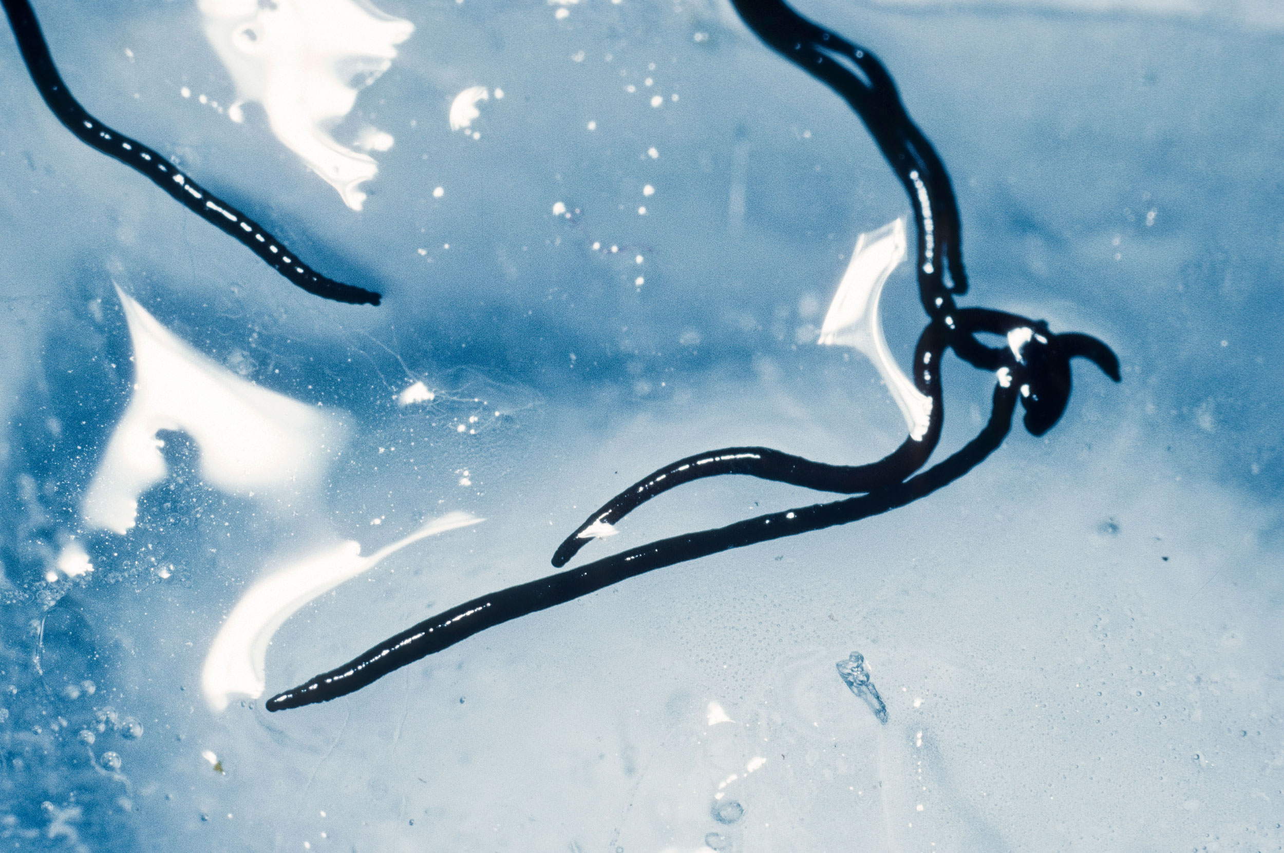
Ice worms, which stretch up to four centimeters long, are often found in the glacial melt of the Pacific Northwest. Photo by Accent Alaska.com/Alamy Stock Photo
Easton’s icy world shifts and creaks, and the babble of water fills the air, sounding like a bass drum as it hits the ice, and a soprano rush and gurgle as it races along. Below the surface, the meltwater forms channels and tubes called moulins, then emerges at what are called supraglacial streams. At one such stream, Pelto and the crew pause, first to fill their water bottles. “That’s the good stuff,” Dryak exclaims, and everyone drinks deeply for several minutes. Then they measure the velocity of the same stream. Pelto tromps a few meters uphill and pours a bottle of biodegradable fluorescent-green dye into the water, and McConnell pulls out a stopwatch and records how long it takes for the dye to pass below. This is not a typical glacier measurement, but Pelto feels that one might glean new information about glacier behavior by paying attention to such streams and how they evolve, mature, and change shape and speed.
The day is full of such acts of measurement, in metric and imperial depending on the instrument. Pelto carries a nine-foot steel pole, notched with foot and inch markings for gauging depth, and stops at miscellaneous locations to tap it into the snow like a fence post. The pole also has a second function—as a crevasse finder. As we enter the icefall, he taps the pole into a flat, smooth layer of snow and it drops easily, tracking nothing solid, slipping into emptiness beneath. We wend through a labyrinth of crevasses—some making wide, visible slashes across the ice, others hidden—and whenever we need to cross snow, Pelto has us walk single file as he probes the ground with his pole.
The most common way to check the health of a glacier is to calculate mass balance—an icy accounting of profits and losses—by taking field measurements of the snow depth and the height of the glacier and combining it with a range of data from satellites and weather records to estimate the gains and losses of ice and snow. Pelto is also a collector of miscellaneous observations and data—the way some people collect curios or colorful stones—with the idea that they may at some point allow him or other scientists to learn or create something. On another glacier, he counts goats every year, though he has no zoological background. Jill, in similar spirit, has taken it upon herself to measure crevasse depth, and she perches at the edges of some of the most fearsome-looking cavities and unspools a plumb line into each. She asks us to take bets on how deep each crevasse is. Most are around 10 or 12 meters. A healthy glacier has many deep crevasses, says Pelto, the way a healthy brain has many folds.
By pouring a bottle of biodegradable fluorescent-green dye into the water, scientists can measure the speed of the water flow from glaciers. Video courtesy of Mauri Pelto
But the ultimate goal—to create a detailed portrait of the Easton, its behavior, its past, its future—is not theoretical. Across from us, through cloud and fog, appears another white shape—the Deming Glacier, which is part of the water supply for the approximately 90,000-person coastal city of Bellingham, Washington, midway between Seattle and Vancouver, British Columbia. Pelto doesn’t visit the Deming because it is so steep it’s almost inaccessible. But the Easton is a stand-in, and they are both shrinking.
The worst moment for Pelto’s glaciers so far came in 2015. A winter of sparse snow followed by a record hot summer robbed the glaciers of more ice and snow than any other season in the past 50 years. (The same season churned up the largest fires on record in Washington State and filled Seattle skies with acrid smoke.) That season, Pelto became emotional with each glacier visit. “The glaciers just looked naked. Only two of the glaciers had any snow at all on them,” he remembers. “You just had a sense—these things are going to lose so much this year. They’re never going to get it back.”
It was also a glimpse of things to come: “2015 was a perfect year that we use as a surrogate for what we think the future might be,” says Oliver Grah, the water resources program manager for the Nooksack Indian Tribe, an Indigenous community whose administrative headquarters lie along the Nooksack River, halfway between Bellingham, at the river’s mouth, and Mount Baker, whose glaciers feed the river.
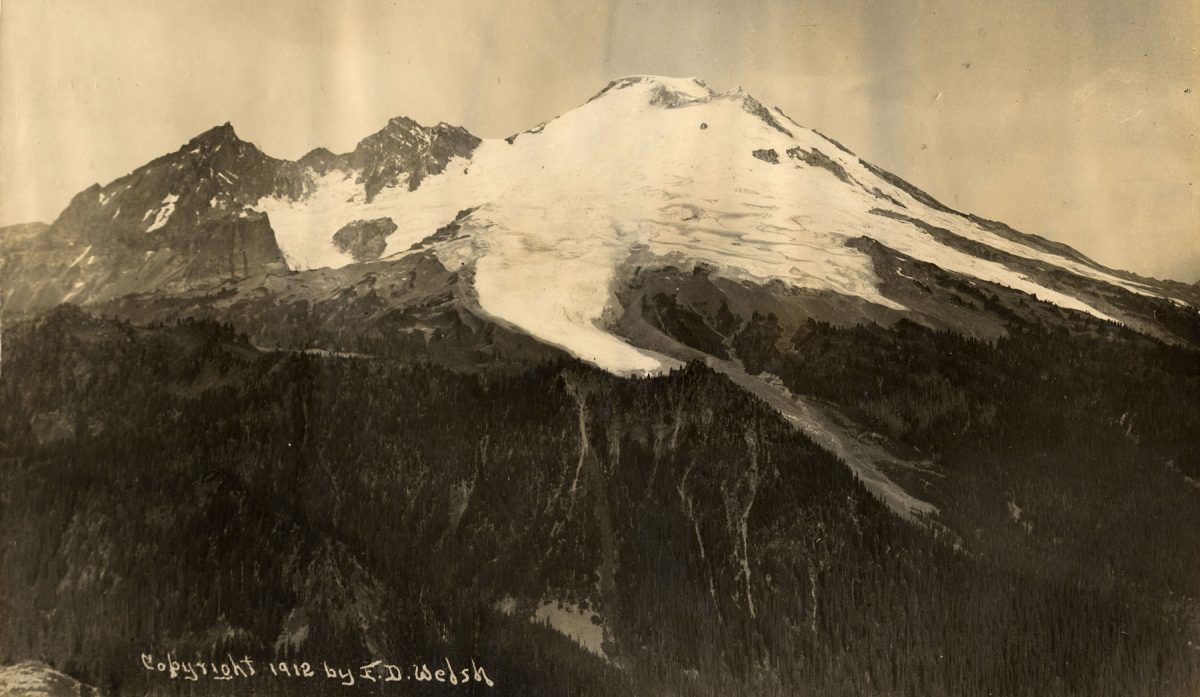
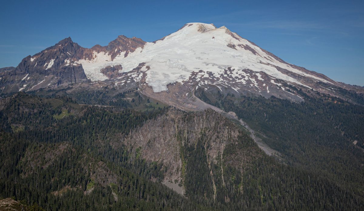
Easton Glacier in 1912 and in 2012. Photos by E. D. Welsh (1912) and John Scurlock/Jagged Ridge Imaging (2012)
The name Nooksack derives from a place name meaning “always bracken fern roots.” According to the community’s oral histories, the Nooksack have always lived in this watershed. Anthropological and archaeological research documents the Nooksack people’s presence from the upper elevations of Mount Baker to the river’s mouth at Bellingham Bay and northward across the US-Canada border. They were only officially recognized by the US government in 1973 and currently have about 2,000 enrolled members and a modest set of offices across from some railroad tracks in the rural, unincorporated town of Deming. But they employ 15 natural resource scientists and research technicians and run an ongoing glacier hydrology research program.
Grah—who is not a tribal member but has worked for the tribe since 2011—monitors water and streamflow along the Nooksack River, which has three forks. The middle and north forks are fed by four and 12 glaciers respectively, but the warmer south fork receives almost no glacial meltwater. The north can be as much as 5 °C colder than the south. Nine species of Pacific salmonids, including trout, migrate up these streambeds, but, because of the glaciers, the middle and north forks offer a safer, cooler refuge for chinook and chum in hot summer months. The salmon are paramount to Nooksack culture and diet, and the tribe has a federally protected legal right to fish in this watershed based on an 18th-century treaty.
The glaciers supply the cool water that keeps the fish healthy. When Grah and Pelto met in 2012, both saw the potential for collaborating. Two years later, the tribe began assisting Pelto with some of his research costs—via grants from the US Environmental Protection Agency and the US Bureau of Indian Affairs—in exchange for help setting up their own program to study glacier outflow. Grah and some of his colleagues trekked 11 kilometers into the wilderness on foot to set up and then regularly check a gauge at the base of the Sholes Glacier, which flows into the north fork. In August 2015, they noticed that there was slightly more water coming from the glacier as the intense heat melted more ice, but also, as the glacier’s retreat laid bare the earth beneath it, more sediment and dirt filling the streams below.
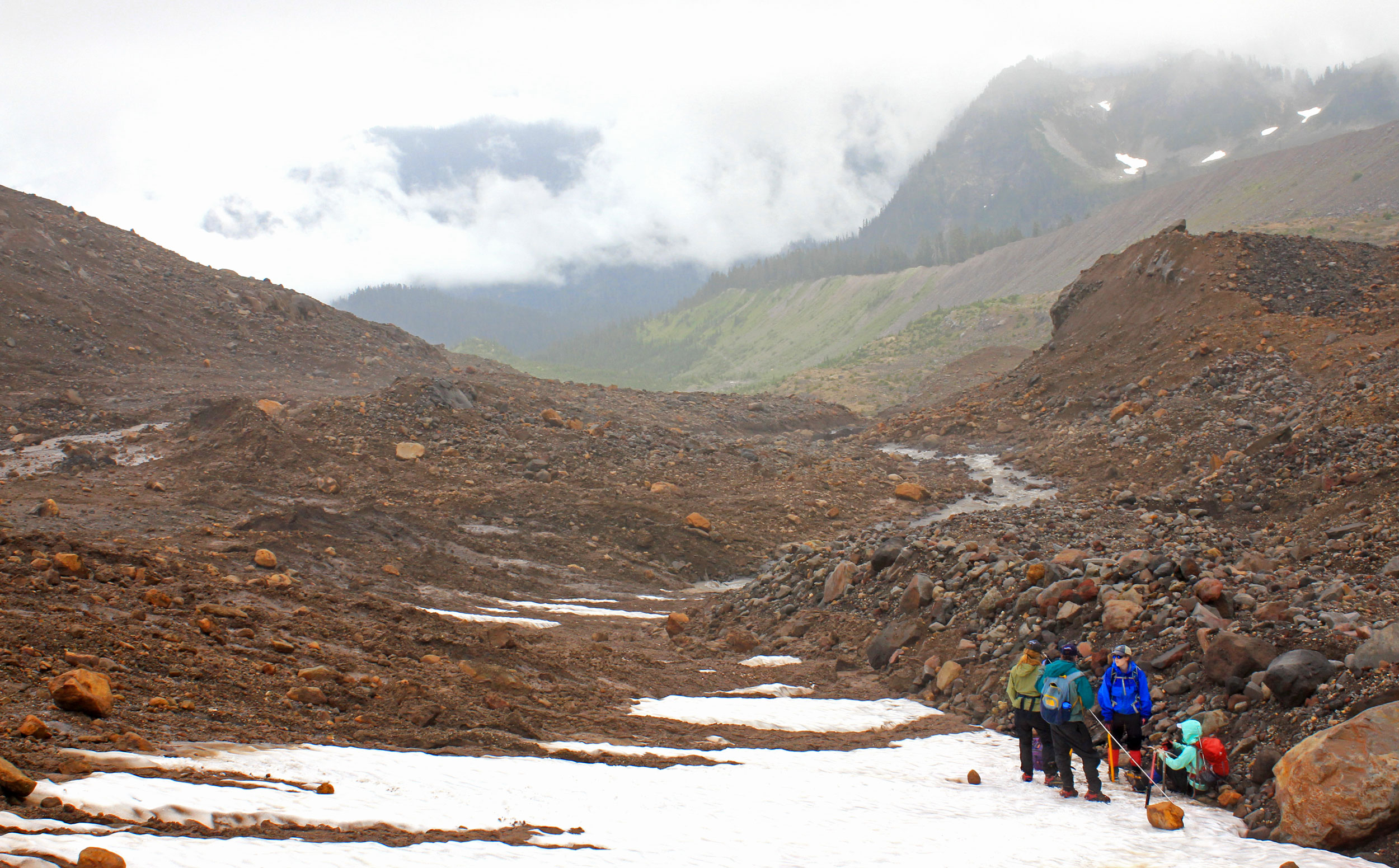
The last couple of summers have been some of the hottest in the Cascade Range. The terminus, or lowest point, of the Easton Glacier—where the researchers are standing—continues to melt and recede. From left: Jill Pelto, Mauri Pelto, Mariama Dryak, and Erin McConnell. Photo by Madeline Ostrander
The streamflow increase was temporary. Pelto says the outflow produced by glaciers in the Cascades peaked in the 1990s and has been, on average, declining ever since. If the glaciers shrink enough, the amount of water they offer to the region’s rivers could drop to a trickle. The heat and erosion could be long-term problems. Salmon need clear water to see the insects and larvae they eat, and they can’t stand temperatures much higher than 20 °C. “It’s summers like this that are killing us for coho,” says Ned Currence, a fish biologist and Grah’s colleague at the tribal headquarters.
On a late-summer day in 2018, I visit a spot on the south fork at the edge of farmland where Currence and another fish biologist, Treva Coe, oversee the construction of a logjam. Stacked at the edge of the stream channel is a pile of wood—logs and fallen trees, many of them with a massive rootball still attached. The logjam’s ultimate destination, a spot several meters farther into the water, is demarcated by white sandbags where a crew of mostly tribal members is seining fish to make way for the wood. The fish will eventually be allowed to swim into the cool hiding places the logjam is meant to provide: the tribe has installed more than 200 of these throughout all three tributaries and is also replanting trees along the water’s edge to create shade.
But will it be enough if summer days are regularly like this one? The air is over 30 °C and the sun glares—so hot that Coe insists on yanking off a pair of heavy khaki waders and boots and, with meek apologies, dipping into the river for a swim midway through our interview.
It may be hard to replace the cooling power of high mountain glaciers.
As we conclude our expedition up the Easton, I follow Pelto and his crew to a high, flat bench of snow that gets progressively deeper, from one and a half to three and a half meters at the top. The upper zone of the glacier is colder than the lower, simply because of the elevation difference, so it retains more snow. It is known as the accumulation zone. It is like the glacier’s mouth and stomach, taking in sustenance that supports the entire body of ice.
Because glaciers like this are so large, high, and dynamic, Pelto thinks some claims about their hasty demise may be exaggerated, particularly the estimate that Glacier National Park (the US park not the Canadian one) will lose all of its 26 remaining eponymous ice bodies in just over a decade.
“People always ask, ‘How soon is it going to disappear? They’re melting so fast,’” he says. He points to a deep crevasse ahead of us. “But then you see how thick the ice is at a place like this. And then we’re nowhere near the thickest place of the ice.”
In this illustration, Jill Pelto depicts herself measuring crevasse depth as she hikes a glacier. Illustration by Jill Pelto
Whether glaciers vanish altogether or not, he insists, misses the point. Glaciers are not simply curiosities or aesthetic objects, not things we should regard with mere sentimental interest. As they lose their foothold and prominence in places like this, we will feel the effects downstream, more powerfully than most people realize. But because glaciers are usually out of sight or far above us, we have failed to appreciate them. Even today, few models of climate change or hydrology adequately account for the role of glaciers. Their losses will be felt regionally and globally: mountain glacier melt makes a substantial contribution to sea level rise.
Much of the Pelto family is now involved in telling the story of glaciers. Jill has become a well-known artist and has created a series of vivid watercolors depicting various aspects of climate change, including the loss of glacial ice. Pelto’s son, Ben, is pursuing a PhD in glaciology at the University of Northern British Columbia. And for the past decade, Pelto has kept a blog called From a Glacier’s Perspective, now hosted by the American Geophysical Union, which offers observations about the world’s glaciers, including those he studies, albeit in relatively technical language. In 2017, a period of higher-than-normal snowfall followed by a record hot and parched summer, Pelto reported that his glaciers retreated an average of 12 meters at their bases. In March 2018, on his blog, he recounted the story of the annual monitoring of Easton Glacier since 1990. He has taken more than 5,000 measurements of its snow depth and melt in those nearly three decades, and the Easton has shed a quarter of its ice volume, slowed its movements, and lost crevasses. It is, in other words, slowly wasting away.
“There’s a lot of different stories,” he says. “The glaciers are suffering. I can tell that one glacier at a time. Each person cares about this certain glacier in their backyard.” But I wonder how many people consider them when they are distant and shrouded in cloud. And this may be Pelto’s true contribution—year after year, to document and try to make clear how much life and complexity is part of the high mountains.
We descend from the snow basin back toward camp. The researchers will stay on to take more measurements the next day, but I repack my belongings and prepare to head downslope alone. Pelto gives me directions to follow a ridge above the streambed that offers easier passage. In daylight, the return journey is like a walk through time-lapse photography—the picture of glacial influence and retreat in just a few kilometers. A field of rocks and mud turns to grasses and marshes. A waterfall and then a roaring stream burst from the hillside. Seedlings and then larger saplings appear, then dense clumps of alders. As I hike down along a trail, the trees rise until they become tall, old-growth cedars and firs. Between here and the coast are hundreds of square kilometers of forests and fish and animals, patches of farmland, rural towns, and urban areas.
Glaciers, our benefactors, helped forge and feed these places for millennia. As they retreat, it will be no small thing to learn how to manage without them.
Correction: The Deming Glacier contributes to Bellingham’s water supply but does not drive a hydroelectric dam as originally reported.