
Keeping Watch Over Seabirds at the World’s Edge
In Alaska, one of the longest-running and most comprehensive seabird monitoring projects is equal parts tedium, adventure, truth, and beauty.
Article body copy
Watch a recording of the web event from January 14, 2021 for a discussion about Gilman’s experiences on St. Matthew Island.
The half-sunk ship looks like something torn off a steampunk dirigible. The masts and stack jag crazily. Doorways gape. Part of the hull, torn off, points skyward a short distance away, leaving a corroded warren of chambers exposed below midship decks. Sea flows through the gaps. This wreck is the Milos Reefer, a Greek cargo vessel that dragged onto the rocks in 1989 and has been marooned here, disintegrating at the edge of St. Matthew Island, a rugged, 50-kilometer strip of land in the Bering Sea far off Alaska’s west coast, ever since.
“Is that a kittiwake nest?” exclaims Marc Romano, squinting deep-set eyes to his binoculars, as we bob nearby in a skiff. Indeed, a messy puck of mud and grass crowns a mast, lorded over by a black-legged kittiwake, a small, gull-like seabird with black wing tips and a squeeze-toy cry. Streaks of guano roll down the deck from another nest, tucked into a corner. Guillemots careen out of broken windows toward us, forcing us to yelp and duck before they bank at the last second, as startled by the encounter as we are.
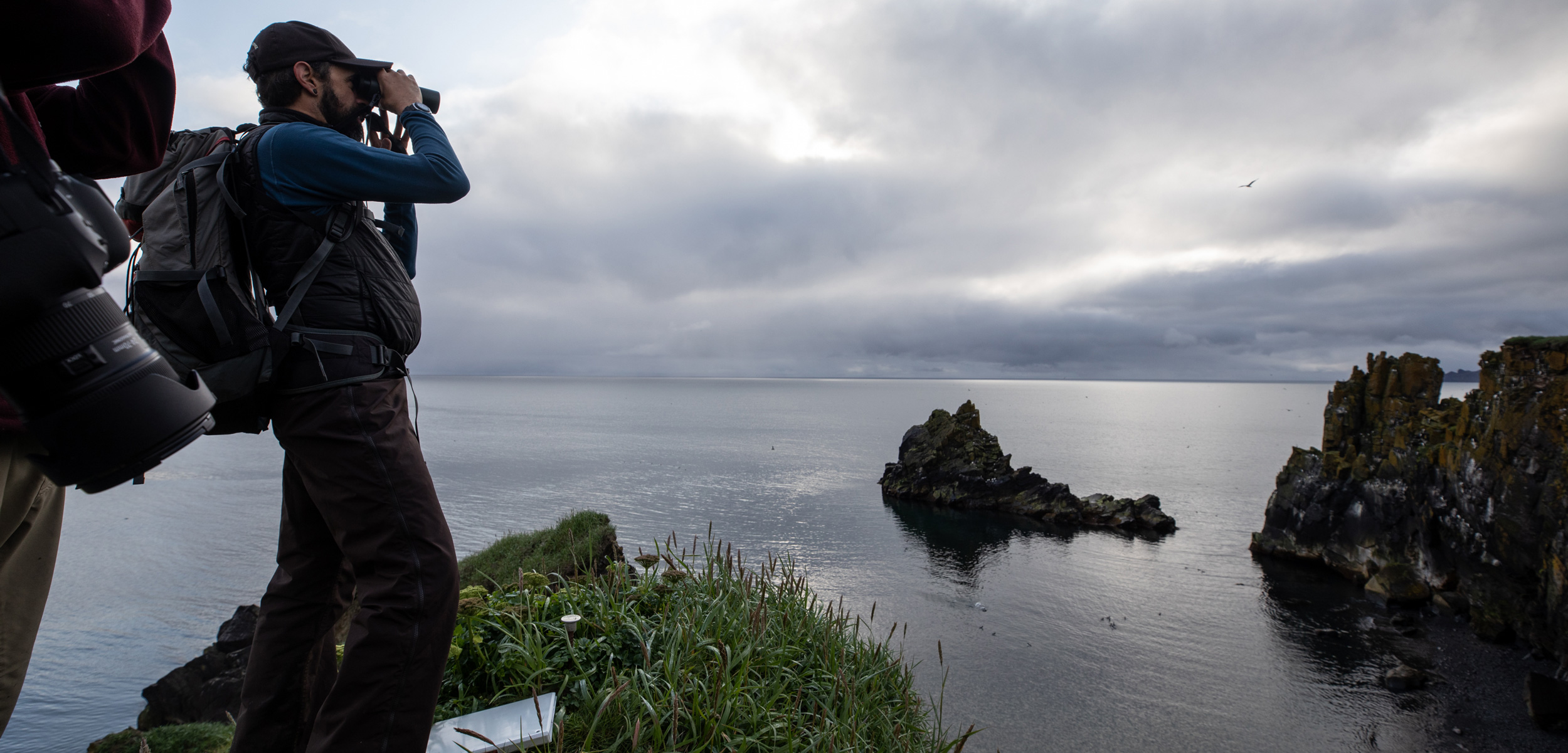
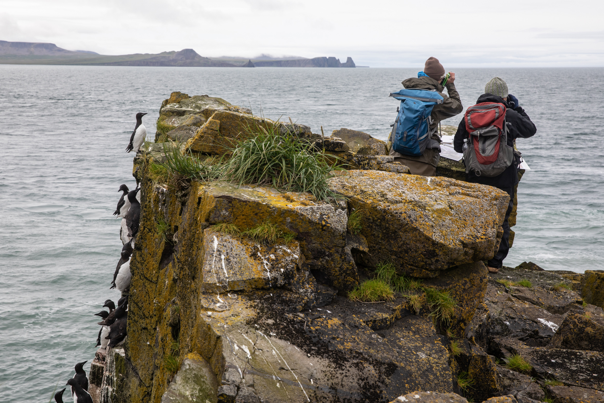
“Brand new ledge-nester habitat,” says Robb Kaler, joking that the crew should add the shipwreck as a stop on their survey route. The three men aboard the skiff, dressed in flame-orange and yellow flotation gear, are scientists for the US Fish and Wildlife Service, here to circumnavigate St. Matthew and its two neighbors, Hall Island and Pinnacle Island, over the next nine days to census some of the birds that nest on their towering cliffs. Some 1.6 million seabirds of 12 species arrive in the uninhabited archipelago each summer to breed and rear young. Kaler, a seabird biologist at the agency’s migratory bird office in Anchorage, and Aaron Christ, the biometrician for the Alaska Maritime National Wildlife Refuge, scan St. Matthew’s precipitous coastline, divided into short sections for easier counting, and tally every kittiwake and pelagic cormorant they see roosting there. Romano, the refuge’s biologist for the Bering and Chukchi Seas, including these islands, keeps the skiff from following the Milos Reefer onto the rocks.
Romano slows the outboard and sneaks us between the wreck and a five-story archway of glossy columnar basalt, then motors an arm’s length away around another sea stack, its lichen-spattered rays of stone fanned like the feathers of a splayed wing. In shade, clouds of backlit birds above glow like fireflies. In sun, flocks of their shadows wheel and loop across the high rock faces.
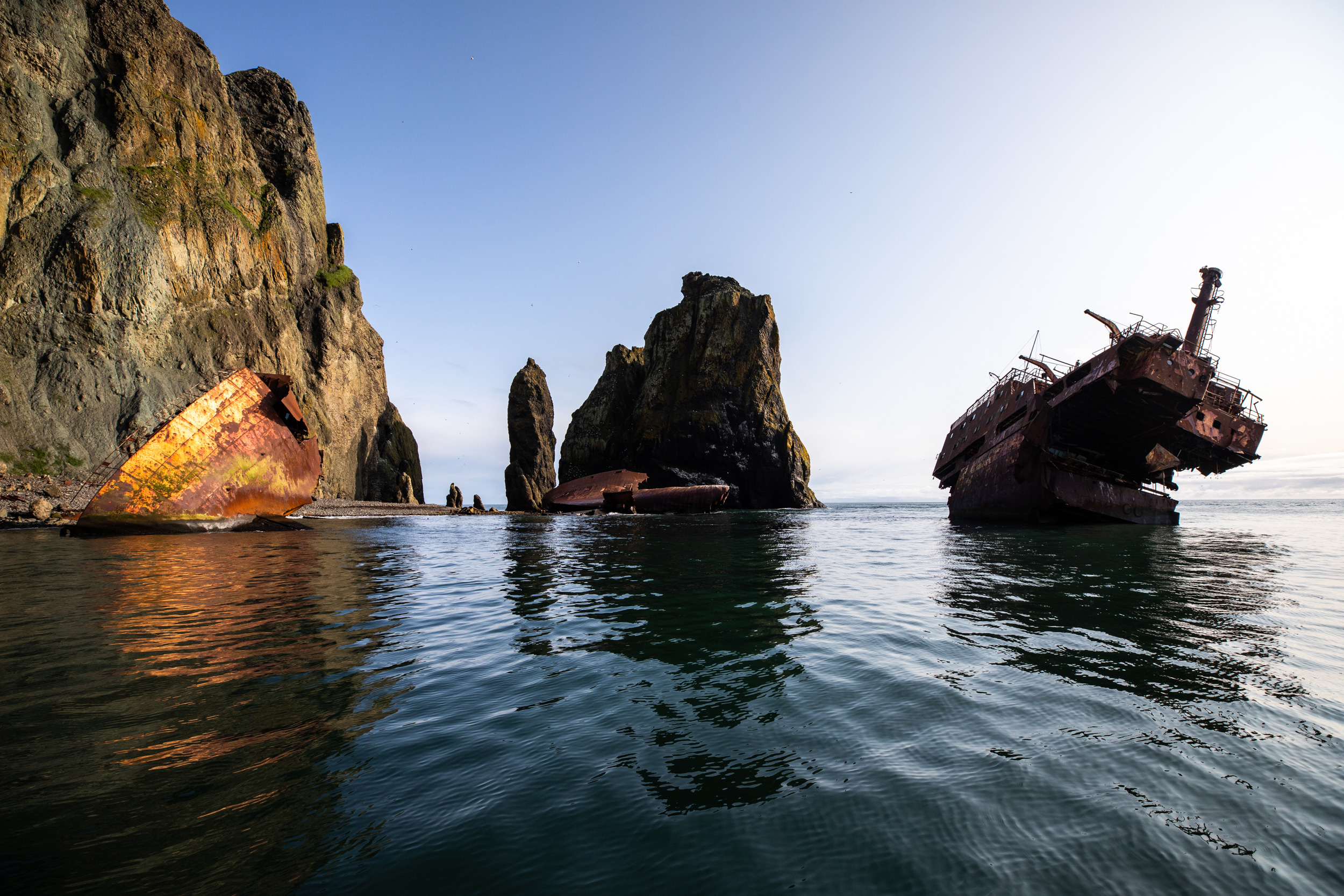
The Milos Reefer, a Greek cargo vessel, wrecked off the northeast coast of St. Matthew Island, Alaska, in 1989.
“We get to see stuff like this a lot,” Romano says quietly as we make our way slowly along the cliffs. The refuge’s 37-meter research vessel, the Tiĝlax̂, delivers staff to some of the state’s farthest and wildest corners: the long arc of the Aleutians, slung across the Pacific from North America to Asia; the bird-spackled heights of the Pribilof Islands, some of the nearest land masses at more than 350 kilometers to the south of us. The scientists have watched humpbacks breach and killer whales devour seals. They’ve been pounded and tossed by storms. “But this,” Romano says, “this is really special.” Because St. Matthew is so far from anything and so expensive to reach, the Tiĝlax̂ has rarely sailed here more than once every five years, until recently. When it does come, the weather often makes skiff surveys difficult, with fog down to the decks or the sea hurling itself against the islands in 10-meter explosions of spray. On this July day in 2019, though, the water is glassy, the sky clear. We can get close enough to feel small.
“We are but a crumb on God’s table,” Kaler says solemnly.
“You’re reaching now,” I say.
“We are but a crumb in God’s beard,” he tries. “But actually, that infers that God’s male, and I’m not sure how she would feel about that.”
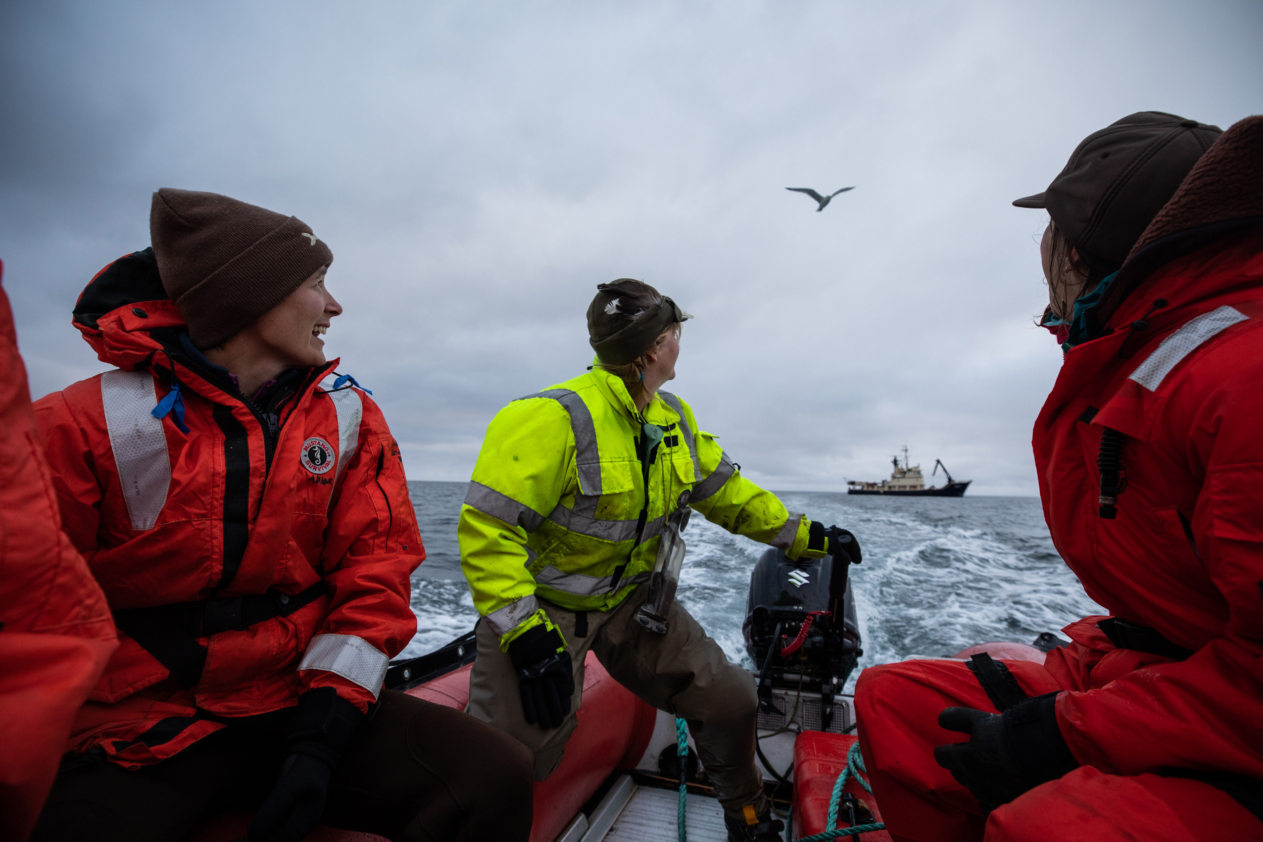
Brie Drummond (left), biologist for the Gulf of Alaska and Alaska Peninsula units of the Alaska Maritime National Wildlife Refuge; Jen Smola (center), deckhand for the refuge’s research vessel, the Tiĝlax̂; and author Sarah Gilman (right) motor away from the Tiĝlax̂.
When we return that afternoon to the Tiĝlax̂, Romano stays on deck for a long time, looking back. It’s only our first day; changing conditions could easily thwart the dozens of kilometers of coastline bird counts that remain. But he marvels again at the calm. It feels like permission, an invitation to witness another world.
That’s why we’re here: to witness. I’m tagging along as Romano and other scientists aboard the Tiĝlax̂ gather key local information to add to the reams of seabird data that refuge scientists and allies have amassed from Alaska’s islands and coasts over the last few decades—one of the longest, largest, and most comprehensive seabird monitoring efforts in the world. The aim is to track change, particularly in numbers and breeding success. Perhaps paramount, scientists hope to catch losses in time to determine what they mean and whether they’re possible to stem. And to know what’s lost, you must first know what’s there.
Watching animals is, of course, nothing new in Alaska. Indigenous people like the Yup’ik, Iñupiat, and Unangan, or Aleut, have long histories of relying on seabirds for eggs, meat, and skins, and have marked the birds’ arrival and progress at their breeding cliffs each season for generations. Western science’s broad involvement here is much shorter, and in many ways, it begins with oil.
In 1973, the US government set out to understand what was in the ocean off the nation’s shores, not for any grand scientific purpose, but because a new environmental law required it to conduct thorough reviews before it could sell leases to offshore areas for drilling, to weigh risks and measure impacts should a disaster occur. Up to that point, the Fish and Wildlife Service in Alaska didn’t do much research on marine life, says Vernon Byrd, a biologist with the agency at the time. Then, a manager from one of the federal agencies responsible for overseeing the reviews told local officials that a tsunami of money was coming, so “‘you’re going to need to step up to plate, because this is going to be the biggest deal you ever saw,’” Byrd recalls. “Any [biologist] that could say seabird was hired.”

Seabirds, including common murres and thick-billed murres, nest each summer on difficult-to-access cliffs and sea stacks like these on the northwestern coast of St. Matthew Island, in the Bering Sea.
Among the generation of scientists launched in Alaska and elsewhere by the cumbersomely titled Outer Continental Shelf Environmental Assessment Program (OCSEAP) was Art Sowls. Sowls had just finished a seasonal job driving a garbage truck and doing other miscellaneous tasks in southern Alaska’s Kenai National Wildlife Refuge when the Fish and Wildlife Service tapped him to survey marine birds and mammals from a coast guard icebreaker. Though he had a degree in biology, he had never seen a whale, and he knew little about seabirds. But he became adept enough at the work that, in 1977, a government research vessel left him and a biologist named Tony DeGange on St. Matthew for a month with an inflatable motorboat, to conduct the first scientific census of the island’s birds. Still other teams traveled to the Pribilofs, to the Gulf of Alaska, to every island and cliff within reach. In 1978, Sowls led the compilation of a catalog the size of a coffee-table book with their findings: Alaska’s known seabird colonies, mapped by location and species, complete with population estimates. The catalog would be updated for decades to come.
Preparations for potential drilling moved rapidly alongside this basic descriptive work, and in the early 1980s, Sowls traveled again to St. Matthew. The archipelago had recently been consolidated with other wildlife refuges to form the Alaska Maritime National Wildlife Refuge, some 2,500 scattered islands, outcrops, and headlands, nearly spanning the state and sheltering most of the colonies listed in the catalog. This time, Sowls—working his way through temporary appointments before ultimately joining refuge staff as Bering Sea unit biologist—was there to gather data for assessing the impacts of a land swap that would allow construction of an oil support base. Development scenarios for the facility, located on St. Matthew’s southeastern tip, envisioned runways, roads, warehouses, a harbor for tankers, an oil processing and storage terminal, pipelines, and more to support drilling in the Navarin Basin to the west. By 1984, the federal government had sold oil leases there and in five other Alaska offshore planning areas.
But it was becoming clear to many of OCSEAP’s participating scientists that simply knowing where seabirds concentrated wasn’t enough to understand how all this development might affect them. You also had to understand their behaviors and natural variations in their numbers over time. In the dry parlance of science, you had to monitor them in a systematic way, preferably for decades. For his master’s, Byrd set off for the Pribilofs to sort out how to do so there, building protocols as helicopters ferried oil crews and equipment overhead. When the Exxon Valdez tanker slicked Prince William Sound, on the other side of the state, with oil in 1989, things kicked into overdrive. “All those data that were collected by every kind of person in every kind of way, scattered around Alaska, and jammed together in the Colony Catalog, all of a sudden needed to stand up in court,” says Byrd. “And man, that got everybody’s attention. It wasn’t the purpose of the surveys to be used for precise evaluation of change, but they got forced into service because there wasn’t anything else.”
The monitoring program that finished developing in the years after the spill, largely under Byrd’s leadership as the refuge’s supervisory wildlife biologist, was designed to do a better job. Initially, it sprawled over 10 sites spread through the state’s major marine ecosystems where crews would monitor birds through most of their breeding season each year. There are eight active today. The refuge picked these places, among them the Pribilofs in the Bering, Aiktak and Buldir Islands in the Aleutians, and Chowiet Island near the Gulf of Alaska, for logistical reasons, too—whether they had a beach to land, a community or a spot flat enough to host a cabin where field techs could live each summer, and an accessible seabird colony with a good mix of species that techs could watch. Many sites were attractive because they could build on plots established during OCSEAP and pull in their data.

Map data by OpenStreetMap via ArcGIS
Crews count different birds at the same reference plots year after year to track visitation to each breeding colony as a proxy for trends in the local population of each species. Since many seabirds are long-lived, techs also record the minute intimacies of their lives, which are affected much more immediately by environmental shifts: when they nest, when they lay eggs, when their chicks poke their way into the world, how well they grow, whether they survive. To extrapolate over a broader region, scientists also try to briefly visit several other islands, among them St. Matthew and neighboring Hall, every few years to see how birds there sync with the consistently monitored colonies.
With some 40 million seabirds nesting in the Alaska Maritime National Wildlife Refuge, the program still offers just “a little tiny snapshot,” says Heather Renner, who took over as supervisory wildlife biologist in 2011 after Byrd retired. But that snapshot captures something vast. Because different species of seabirds eat different creatures and feed from different parts of the ocean—some favoring plankton, others favoring fish, some favoring surface waters, others favoring deeper ones—their welfare offers clues about the health of different parts of their difficult-to-study ecosystems. If planktivorous birds don’t breed one year, for example, it may mean there’s trouble with the tiny creatures that many marine creatures depend on for food, with implications for everything from food web structure to commercial fisheries. “We have long touted seabirds as sentinels of the ocean,” Renner says. “Often you see a change first in them.”

Biologists in a skiff from the Tiĝlax̂ survey for birds inside a circle of towering cliffs on the northwest coast of St. Matthew Island.
But the changes the program began to detect after the Exxon Valdez had little to do with the Alaska oil development that they were set up to track. Environmental and fishermen’s groups defeated the St. Matthew land swap in court, and the oil base was never built. Eight wells drilled in the Navarin Basin were abandoned after yielding “disappointing” results. As of April 2020, the only active leases that remain off Alaska’s coast are in the Beaufort Sea in the Arctic, and Cook Inlet, southwest of Anchorage.
In the meantime, though, another type of hydrocarbon spill has become plainly evident, this one fluming through the atmosphere from automobile tailpipes and power plant smokestacks, leaving little on Earth untouched—including the already wildly changeable Bering Sea.
Surf gnaws at the bottom of a dark cliff on Hall Island’s south end. Every ledge on its 100-meter face vibrates with birds. Most are thick-billed murres, barrel-chested divers with narrow bills and sleek tuxedo plumage. They seem dignified enough until they open their mouths, unleashing a raspy, drunken guffaw: GAAH GAAaah Gaaah gaah gah.
Tony DeGange and Brie Drummond peer at the melee from an adjacent promontory a short distance away, where we hunker amid spongy lichen. The main breeding cliffs on St. Matthew, which looms a few kilometers to the south of us across Sarichef Strait, lack walkable beaches below and are too tall and too widely spaced for a crew to survey effectively from the land above in a short time. So the Tiĝlax̂ has deposited the pair of scientists here on Hall, where long-term monitoring plots were established on the cliffs decades ago, to count the island’s birds and check reproductive activity over the next week. I’ve come along for a day to see them in action.
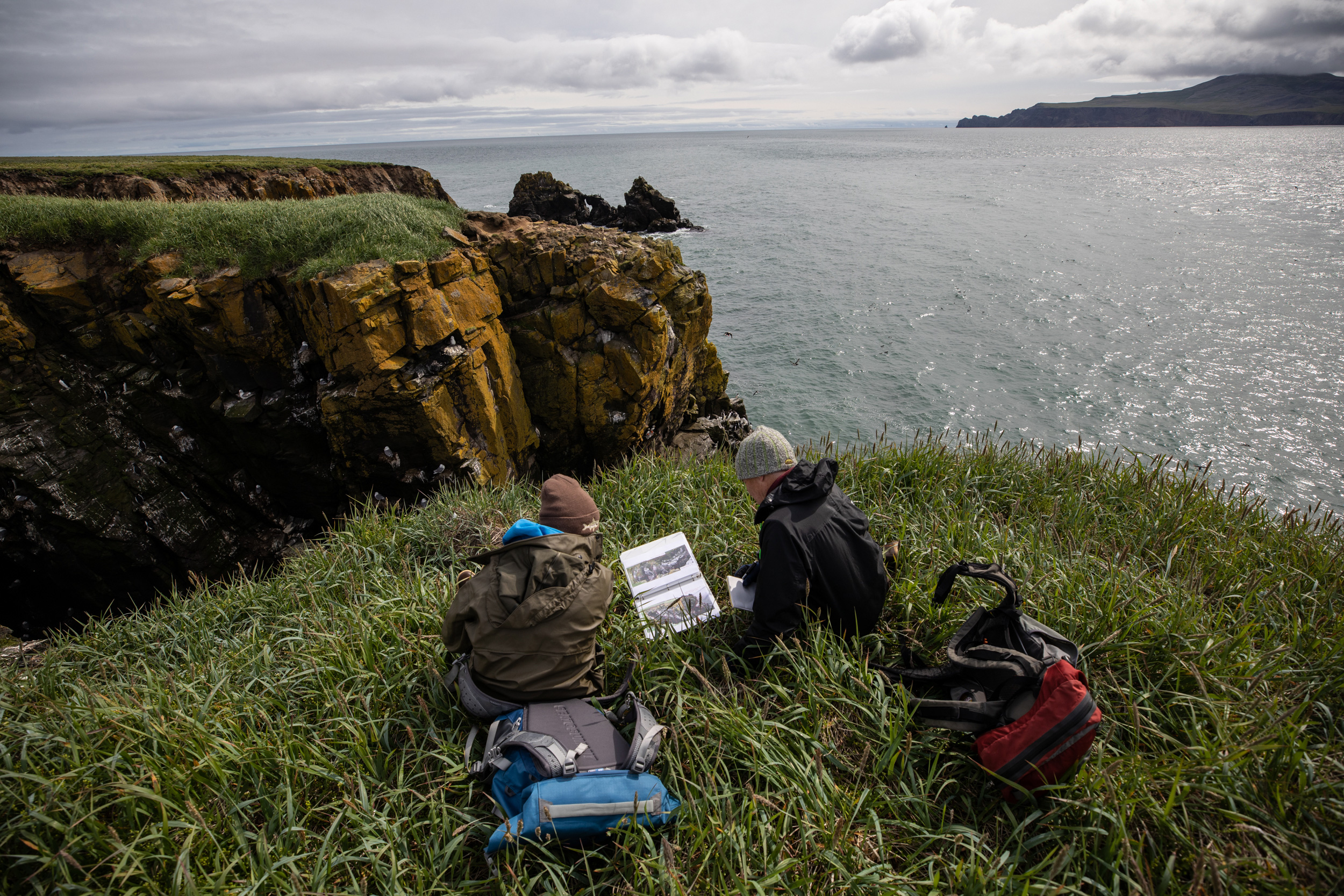
Drummond (left) and biologist Tony DeGange (right) count breeding seabirds from a long-term monitoring plot on Hall Island, Alaska.
“Well …” DeGange says reluctantly, as Drummond flashes a knowing smile.
“Should we just count and see how far apart we are?” she asks.
They lift their binoculars and fall silent, clicking furiously on metal tally counters. DeGange, who accompanied Sowls on that first census of St. Matthew back in 1977, has returned as a volunteer. Drummond, the refuge biologist for the Gulf of Alaska and Alaska Peninsula, got her start as a field tech for the monitoring program on a volcanic island called Kasatochi, where she spent a few seasons before a catastrophic eruption put an end to the seabird colonies there. This loyalty is common among techs, drawn into the work by wildness, completing seasonal migrations to and from their islands that mirror the birds’. As Renner recalled of her own early field seasons in a recent newspaper column: “I remember being told, ‘The first year you come for the experience. The second year you come for the paycheck. The third year you come because you don’t fit anywhere else.’”
“Shit,” DeGange curses, winding his tally counter back.
“I know, I just had to start over, too,” Drummond says, running a hand through her spiky dark hair as the murres’ cackling grows more mocking.
It takes several tries and nearly an hour to finish counting the plot and settle on numbers—about 540 thick-billed murres at this cliff today. The work requires enormous patience—counting nests, distinguishing individuals from jostling masses of black backs; sorting thick-billed murres from common murres; searching out the puffins and fulmars tucked into alcoves, tidy as bread loaves; counting every bird of every focal species within a set boundary, marked on a photo of the cliff face for reference. It can be uncomfortable, too, elbows braced into chest or knees to steady binoculars, shoulders hunched to neck, crouched in stillness until you get what you need. Then, you start over at the next plot down the line, and again and again across dozens of plots, and repeat the whole enterprise each day that weather allows over a set time frame—all to get a single average total count for each species across all the plots to represent the season.
But close attention also brings closeness; you notice things, Drummond says. “I’ve definitely seen murres incubating rocks. They kind of check ’em, and then nestle back in, and then they check ’em. And so you think, Oh! It’s an egg! And it’s a rock.” Or sometimes a murre will catch a fish and bring it back to the cliffs to feed its chick, only to find the chick gone, perhaps eaten by a passing gull. “And so they just have this fish in their mouths, and they just stand there looking really forlorn and confused,” says Drummond.
Drummond, DeGange, and nesting murres on Hall Island with St. Matthew Island in the distance.
This time around, what Drummond notices is how few birds are here—there seems to be less than half of what’s visible in the old photos the biologists brought along to identify the plots. When murres incubate, they snuggle down on their eggs with their chests tucked into the cliff face to minimize the chance that the egg will tumble into space. Now, she says, the murres stand, casually eggless, and face the sea. Romano sees the same on St. Matthew: “They were reacting to the boat in ways I’ve never seen murres react to the boat before,” he says later. With no eggs to guard, whole cliffsides flush when the skiff is still 100 meters away—avian rivers fanning across the sky.
The archipelago’s murres have largely failed to reproduce.
Not all that long ago, a colony full of eggless murres would have been unusual. Among seabirds, murres are champions at breeding consistently, perhaps because they’re so versatile. They can fly far and fast, dive hundreds of meters underwater, and eat everything from krill to squid to small fish, insulating themselves against local environmental fluctuations. But they also must consume more than half their body weight each day, and the system seems to be changing in ways that flummox even murres’ flexibility.
In 2013, for example, an alarmingly warm patch of ocean water developed off Alaska and then expanded down the west coast all the way to Mexico—earning the nickname the Blob and the dubious distinction of being the most powerful marine heatwave on record. Common murres—similar to thick-billed, minus a white stripe along the bill—began to wash up on beaches in droves in 2015 and continued to do so into 2016, from Alaska’s Kenai Peninsula to Southern California. Bewildered birds showed up in driveways in Talkeetna, Alaska, more than 100 kilometers from the ocean; they turned up foraging in freshwater rivers. Mostly they died. Nearly all those collected for necropsy told the same story: they had starved to death.
Volunteers, researchers, and wildlife rehabilitators ultimately reported some 62,000 beached common murres along the west coast, according to an analysis published in 2020, led by veteran US Geological Survey seabird researcher John Piatt. Since most never wash ashore, that translates to about 500,000 to one million dead—most in the Gulf of Alaska.

Thick-billed murres protect their eggs by facing toward the cliffs they nest on, preventing the eggs from rolling, or being kicked, off the ledge.
Crews at the refuge’s scattered monitoring sites, including those in the Bering Sea hundreds of kilometers to the west, also picked up signs of trouble over the same time frame. In 2014, the year after the Blob started, some colonies had a banner year for fledglings. Blithe accounts of first chicks peppered the notes that the refuge’s far-flung field crews kept to track their seasons. But perhaps because breeding was expected, techs mostly effused about unusual species they glimpsed, an errant earthquake, a hot shower aboard the Tiĝlax̂ when the ship stopped by with fresh supplies. By 2016, though, the year the Blob and the die-off subsided, many species at many colonies were failing to reproduce, and mournful entries were common. “Some of the murres decided to lay eggs in the last few days. I’m on my knees, asking them, why??? Why bother??? It’s too late!!!!” a tech on St. George Island in the Pribilofs wrote as the breeding season wound to a close.
In the end, 22 complete reproductive failures occurred at monitored common murre colonies from Alaska to California in the three years during and after the die-off—a combination Piatt and coauthors called “unprecedented and astonishing.” The number of common murres attending colonies in the Bering Sea dropped by more than 80 percent; in the Gulf of Alaska, they dropped more than 50 percent. The researchers theorized that smaller forage fish the birds relied on for food had struggled to find enough food of their own as the heat reduced phytoplankton and favored less energy-rich species of zooplankton. Meanwhile, the heat upped the metabolic demands of larger fish, leading them to eat more forage fish. That left less food for everyone. In addition to the birds, sea lion pups starved; skinny and stranded whales abounded.
As we embarked on our own monitoring journey in 2019, Romano had asked us to keep our eyes open for anything similarly strange. In the years since the Blob, the Bering Sea had seen some of the lowest mean sea ice extents ever recorded, thanks to factors like persistently high ocean temperatures and warm winds from the south. Sea ice plays a key role in jump-starting ecological productivity in the northern Bering each spring, beginning with a bloom of algae as the ice melts. It also seeds a body of extra-cold water on the ocean floor that acts as a barrier, keeping fish species like walleye pollock out of the sea’s northern reaches. This “cold pool,” as it’s called, had barely formed in two years.
Romano had more concrete reasons to worry, too. In 2018, when the Tiĝlax̂ came to St. Matthew to support surveys for an endemic songbird, biologists had discovered hundreds of dead seabirds, strewn down a short stretch of beach—suggesting a mass die-off in a previous year that they had missed. They also found several dead walruses. Murres mostly failed to reproduce throughout the eastern Chukchi and northern Bering Seas—much as they had in the Gulf of Alaska and southeastern Bering during and after the Blob. Then, in the spring of 2019, federal officials had declared “unusual mortality events” for gray whales; one for ice seals would follow shortly. But aside from the chest-out, eggless murres and an eerily empty auklet colony, we see nothing glaringly awry as we explore St. Matthew and its neighbors in the waning days of July.

Seabirds fly between the islands and sea stacks off the northwest coast of St. Matthew Island.
Pinning any one of these things on climate change is tricky, and it’s the same with fluctuations in bird numbers and reproduction that the monitoring program picks up, Romano says. That’s because the Bering Sea is “a schizophrenic mixed bag.” It’s already inherently variable, its food web intricate, and its fate hitched to a natural climate cycle called the Pacific Decadal Oscillation that moves between warm and cool phases. In the 1970s, for example, the Bering underwent a massive “regime shift” to warmer water, and the ecosystem rearranged. In the last couple of decades, it has gone through warm and cold periods, called stanzas, lasting a few years each. But annual sea surface temperatures in the Bering for the last seven years have been in the top 10 warmest in recorded history, according to Alaska climate specialist Rick Thoman. And recent studies suggest that human-caused climate change helped build the Blob and will make similar events likelier, longer, and more intense.
One lingering-twilight evening, as the Tiĝlax̂ sways steeply in the swell, I join Romano on a metal counter in the lab near the stern to watch through the open door as seawater sloshes across the back deck. What if monitoring becomes a long project of documenting decline, and climate policy never catches up enough to help the birds, I ask. “At what point does the information cease to be useful? Do you think about that?”
“I think about it every single day,” Romano says. But “we need to know, as a species, as a country, what’s going on in the world. I think it’s okay to just let people know what’s going on. It’s not all doom and gloom. At some sites, it’s going quite well. It’s also not abnormal [for some species] to have multiple bad years.” That’s another gift of long-term data sets: they give you perspective, and they remind you just how resilient many species have been so far. After their reproductive failure in the Pribilofs in 2016, common and thick-billed murres have been having much better luck rearing chicks there in recent years, he points out. So have kittiwakes, after four years of failure. On one of the islands, Romano says, red-legged kittiwakes laid their first eggs five days earlier than ever recorded.
There will be winners and losers, yes. But there’s no telling yet what the system will become, or exactly why.
The second day of skiff surveys proves less permissive than the first. The Tiĝlax̂ has carried us to St. Matthew’s exposed west coast, where the ship steers in a tight circle to create a disk of calm water so we can more easily hop from the starboard deck onto the waiting skiffs. But as soon as we motor away, hilly swells surround us. To the north, the island’s cliffs crescendo in an eye-catchingly jagged set of towers. A research volunteer on the 2018 songbird survey spotted seabirds near there that may be new to the cliffs of St. Matthew: red-legged kittiwakes, cousins to the nesters we saw on the shipwreck. The plan is to count our way to the towers and confirm that the birds are indeed breeding here, hundreds of kilometers north of their known range. “That big feature doesn’t have a name,” Romano had told me when he first pointed out the towers. “How does that not have a name?!” Then, as if this question was its own answer, he had laughed. “It’s great that it doesn’t. It’s fantastic that it doesn’t!”
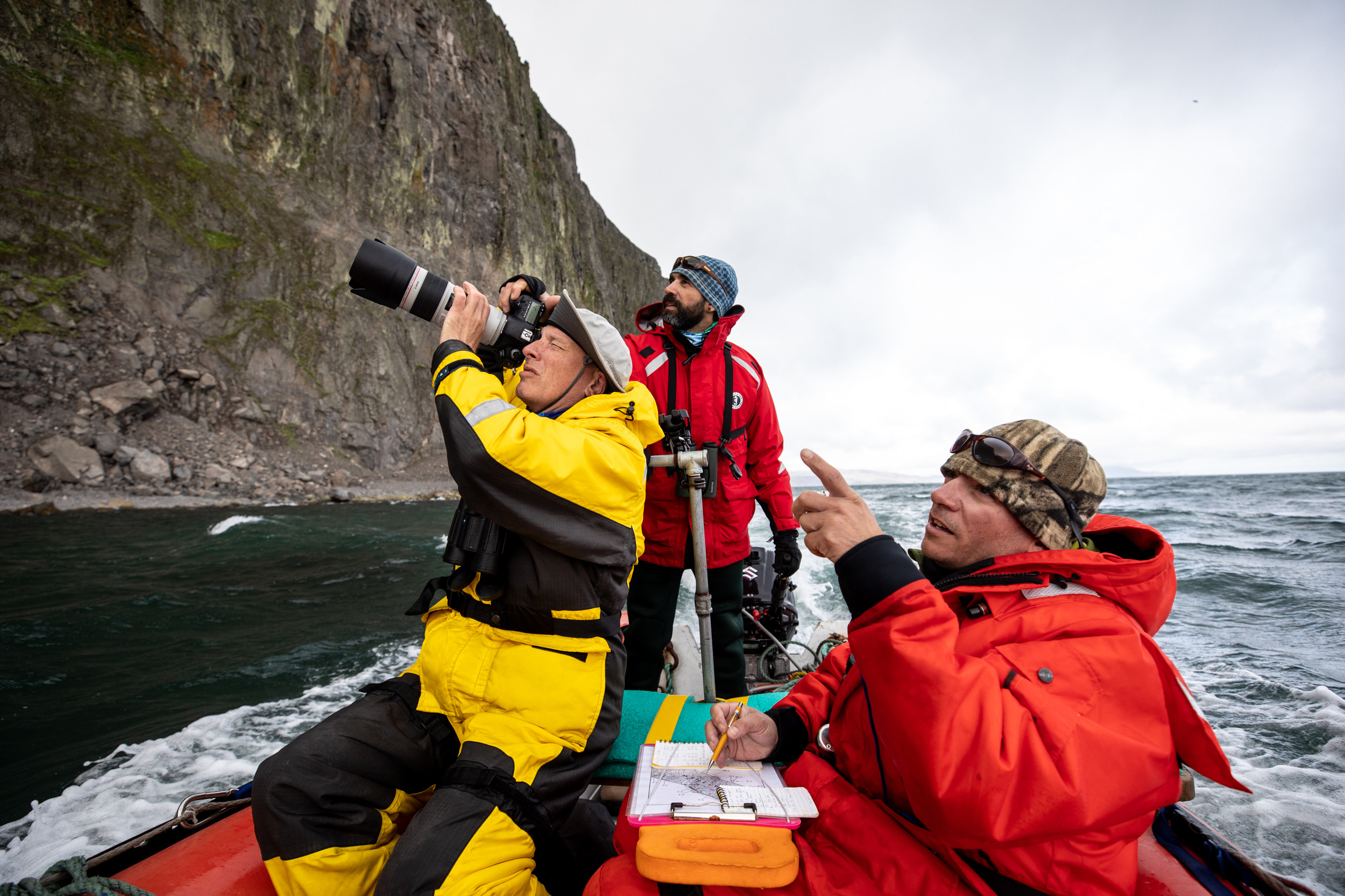
Aaron Christ (left), a biometrician for the Alaska Maritime National Wildlife Refuge; Marc Romano (center), biologist for the Bering Sea and Chukchi Sea units of the refuge; and Robb Kaler (right), a seabird biologist with the US Fish and Wildlife Service, count seabirds off St. Matthew Island.
Still, we need to call it something. And deckhand Jen Smola, steering the other skiff, has settled on Sharkfin Reach. The ominous title suits the conditions. The sun sets the emerald grass crowning the island aglow, but the wind slaps our faces. As we sneak in next to the cliffs for Christ and Kaler to begin scanning for cormorants and kittiwakes, Romano peers around uneasily, then looks back just in time to spot a huge wave barreling in. He turns the bow into it and guns over the crest, popping the marine version of a wheelie, but not before part of the curl breaks over Christ. His sun hat sags around his ears. “It’s good to get a little water over the pontoon, to remind us where we are,” Romano will say later, part in jest, part in apology.
He approaches again, angling the skiff around a reef where breakers curl far out into the Bering, and tucks into the next cove. Christ and Kaler continue to scan, but there are few birds, and no sign of kittiwakes, black- or red-legged. Romano tries to square what we’re seeing with the volunteer’s report. The habitat doesn’t look right. The cliffs are too short and rubbly, and in many places, too accessible to the hungry foxes that prowl the island. As if to emphasize the point, a red fox watches us pass from a small beach.
When we finally ease alongside the towers around midday, though, we hear it: the distinctive squeeze-toy cry. Creeping around the corner into full sun, we find a huge rock face carpeted in black-legged kittiwakes and murres. Beyond, a patch of calm turquoise water beckons from a gap between two of the towers. Romano times the set and powers us through.
On the other side, the world simultaneously opens and closes. It’s as if we’re in a fumarole of birds, a volcano erupting with flight. Columnar basalt walls climb toward the sky on all sides. The rock is birds, every cubby and ledge. The sky is birds, hundreds of them arrowing through the air in all directions. Murres, fulmars, cormorants, auklets, kittiwakes, puffins, more. The spectacle is too big for the frame of my camera. It is too big for my eyes. It is more than language. I try to write in my notebook but manage only one word: religious. On the other skiff, Smola arches back over the pontoon and spreads her arms wide, laughing wildly as the birds rocket over her. I do the same and the sense of rushing motion and deafening sound becomes all encompassing. Murres flap clumsily half a meter above my face, their padded, teddy-bear bodies ruddering left then right, their feet comically splayed, their wings whistling.
And there, sure enough, low on the wall, is a series of mud and grass nests, each with a red-legged kittiwake, belied by its crimson feet, each a point of stillness in the maelstrom of birds, and many with downy new babies. Romano snaps several photos and inspects them, then throws his head back with a huge grin, teeth flashing through his dark beard, completely undone by the results. “Look at that little chicklet! Oh my god!”
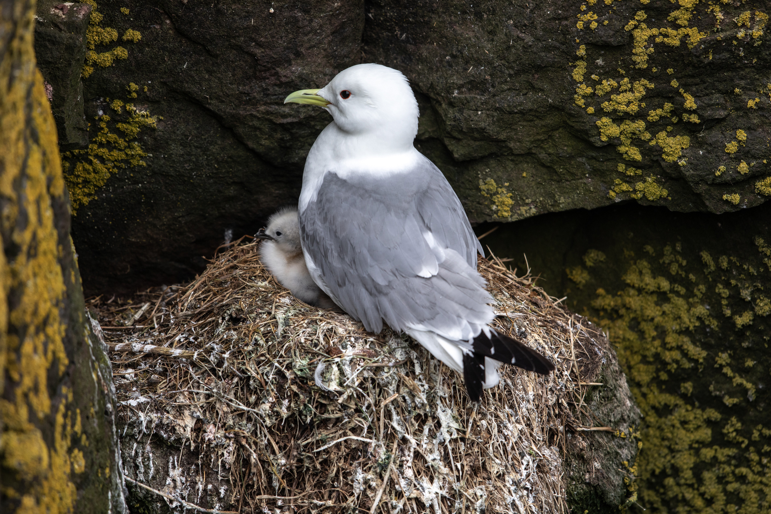
A black-legged kittiwake guards its chick.
The crew ultimately counts 260 adults in and around the towers, with about 100 nests containing chicks. It’s possible, though unlikely, that red-legged kittiwakes have always been here, Romano concedes. There have been a few sightings of adults around the islands over the years, but biologists have also specifically kept an eye out for red-legged kittiwakes among the breeding birds here, without luck. Which suggests another interesting possibility: they may be colonizing new territory. “With all of the changes that are going on in the Bering Sea, it’s not a huge stretch to imagine birds moving north in response,” Romano says. Moreover, red-legged kittiwakes are usually found closer to the edge of the continental shelf, one of the places where their primary prey—lanternfish—migrate to the surface each night from the deep water beyond. Here, they’re surrounded by shallower seas. What are they eating? Romano wonders. And will they show up even farther north? In other words, are they more versatile than science has yet found a way to see?
Answers to those questions won’t likely come soon. With research visits already few and far between, and the pandemic delaying further inquiry, St. Matthew remains a place that defies easy understanding. Perhaps it’s no surprise, then, that by the time we return to the ship, the island has shed the name Sharkfin Reach like so much rainwater. For a time, the crew tries calling the interior of the tower formation the Grotto, instead. Then, one night, the tall, taciturn first mate, Dave Martindell, stoops into the galley on his way to start the coffee pot for his night shift. “It’s going to be the St. Matthew Thunderdome,” he announces to the handful of scientists and crew hunched over the dining tables eating ice cream and entering data.
“What’s wrong with the Grotto?” someone asks.
“I like the sound of it, but it’s not a grotto,” Martindell says, at least not according to the dictionary definition, which he’d consulted earlier on the bridge. He squints, reconsidering his own logic: “We’re going to keep thinking about it, because it’s not a dome either. Everyone write two ideas on the whiteboard.”
Christ glances around. “Frontal Basalt!”
“The Kragon’s Lair,” Romano chimes in.
“Lucifer’s Stove,” Kaler says.
“This is all filth!” Martindell says, then hunches back up the stairs with his coffee.
“Let’s call it Dave’s Conundrum,” Christ says.
The next day, the Tiĝlax̂ drops me off on the island’s southeast end, so I can get a good look at the place where the oil support base would have broken ground. The ship disappears around Cape Upright—a trio of evenly spaced mountains with the graceful curves of a body at rest—and my radio falls silent as it passes out of range. Alone for the first time since I set foot on deck, I make my way up a valley between two of the peaks until the wedge of flat tundra below comes into sweeping view, spotted with ponds, threaded with driftwood, stitched here and there with deep green grass and stunted willows. It’s difficult to imagine, now, planes landing in this silent place, where the sea has the most screaming mouth.
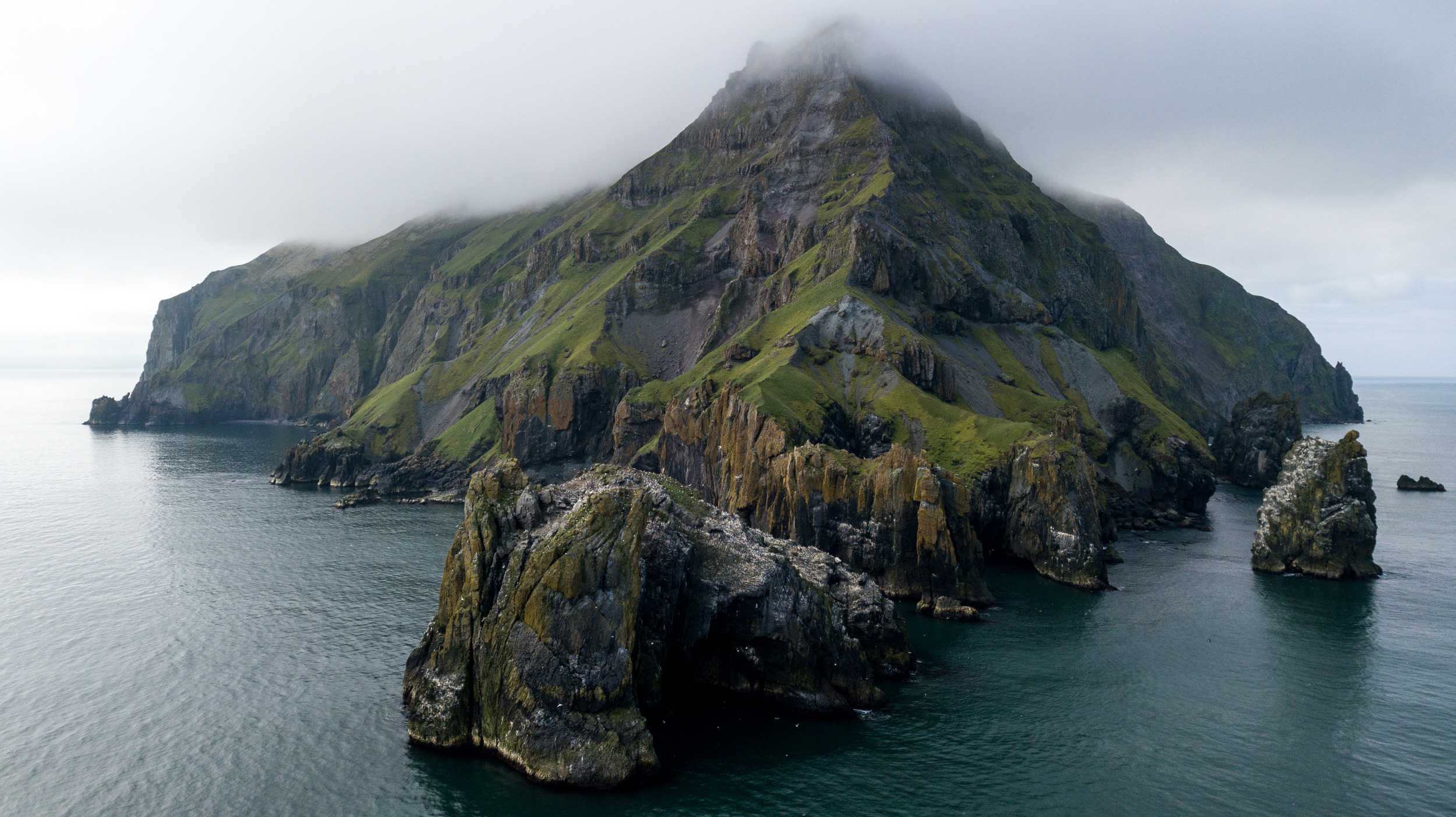
The northern tip of Hall Island, part of the Alaska Maritime National Wildlife Refuge in the Bering Sea.
Clouds drape the summits when I arrive at the top, and I feel the tilting vertigo that comes from nearing an edge. The cries of seabirds make the yawn of space below palpable, where the gentle slopes plunge into multicolored cliffs, the sea eating them away, the birds eking out their future on those ledges before they crumble.
There is a rhythm to this place. The roll of swell and breakers. The rise and retreat of fog. It is not hard here to begin to think of time as a pulse like the tide. Or even to think of land as a tide that rises and falls—pushed upward by geologic forces, subsumed by weather and sea. So why not life? The birds in their shifting multitudes darkening the sky, then waning, then surging again. I realize that perhaps what the monitoring program captures best of all is not loss, but life as flux and constant motion through years, decades, and someday, maybe centuries. The kind of movement that requires careful attention, across generations, to see.
Movement is a difficult thing to pin down with a name. What Martindell seemed to be after was something to call the towers that captured how special the breathing space within felt. What could possibly fit? Soon after my return to the ship for the journey home, I see that all the options have been erased from the whiteboard. In their place, someone has scrawled simply “KRATOR.”
The feature remains nameless.
At last, I leave the Tiĝlax̂ for good at St. George Island in the Pribilofs, where I will catch my flight back to the mainland. I have some time, so I join the field crew monitoring birds here. They lead me down a knotted rope traversing a steep, muddy bank to the base of a cliff plastered with red-legged kittiwake nests. Some 235,000 of the birds come to St. George, their stronghold, each year to breed. Adults like to stay close to their chicks, so the three techs have little trouble plucking them from the ledges with a telescoping noose pole. Each bird is carefully weighed and measured. And each receives two leg bands—a metal one with a unique number and a colored plastic one with a unique number-and-letter code that can be identified with binoculars from a distance, so scientists can note which birds return year after year, following their progress into an uncertain future.
When it’s time to release one of the birds, a tech named Erin Lefkowitz asks if I want to try. I close my hands over hers around the bird’s chest, and my fingers sink into its thickly layered white feathers. It cranes its neck to gaze at me with eyes lined blood red, kicking its equally crimson feet as if swimming. I can feel the quiver of its muscles, the tiny but steady thud of its heartbeat. This is a marvel almost as whirling as the vortex of birds in that circle of stone towers—that something so seemingly delicate persists here at the violent edge of change. I open my hands, and the bird opens its wings.