
Making Amends with Makatea
On this French Polynesian island dramatically scarred from mining, locals grapple with whether a new mine will heal or harm the landscape.
Article body copy
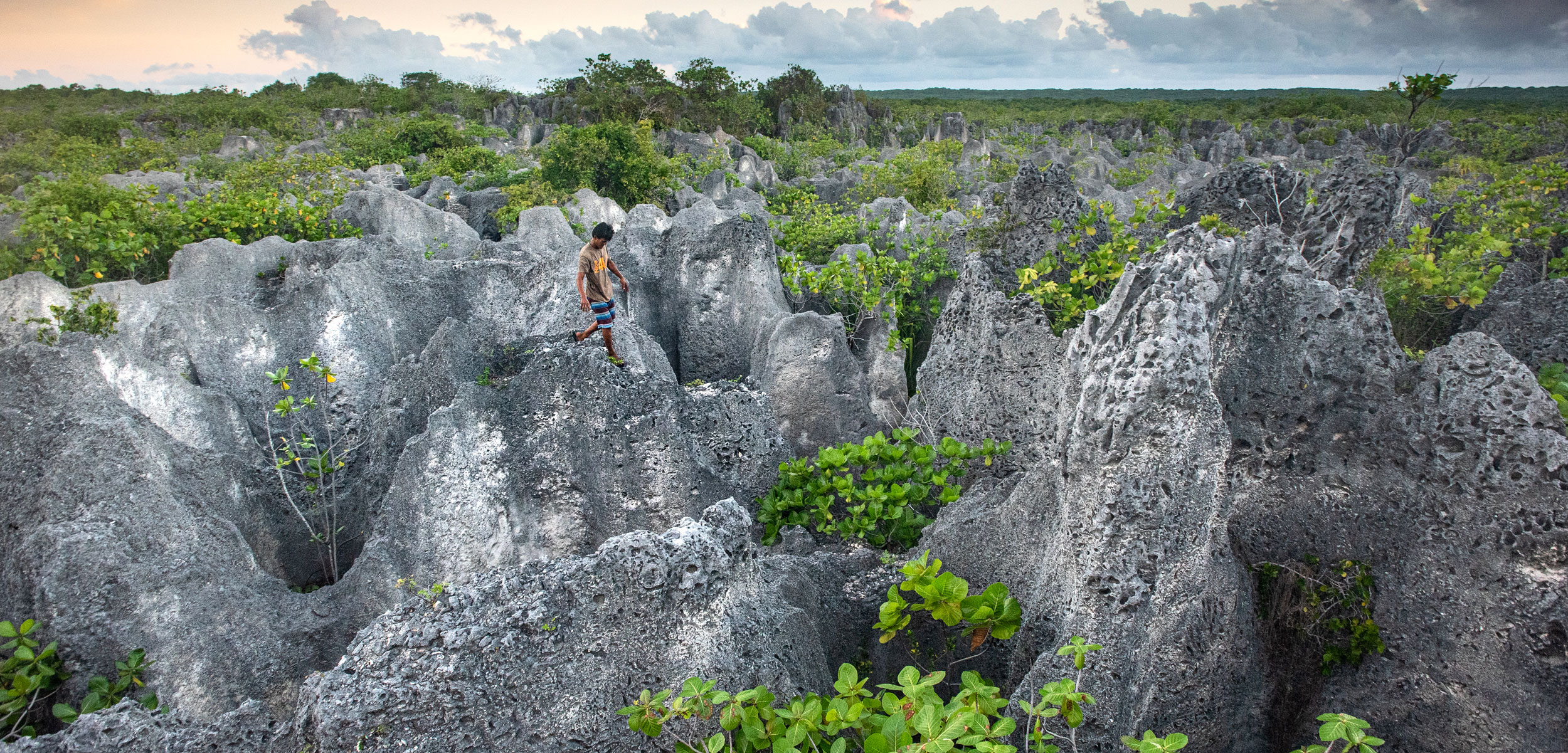
Even in flip-flops, Teiki Ah-scha walks with precision and confidence between the gaping holes on either side of us. He has told me to step exactly where he does, so I watch his feet and block out everything else—the heat, the glaring sun, and the holes themselves, which dominate this rocky landscape. The holes are often several meters across and more than 30 meters deep. In some places, the rock that separates them is barely the width of my foot. It looks like the land has been worked over by a gigantic drill press.
Ah-scha, 31 years old with shiny black hair and a calm smile, doesn’t seem to sweat, though I am dripping. He stops regularly to check on me. When I reach out to steady myself against one of the scraggly pandanus trees that still grow in this scorching terrain, he stops me.
“Be careful of the plants,” he says. “You never know”—meaning you never know if they will come loose and let you fall.
Coconut crab hunters such as Teiki Ah-scha often cross the old phosphate extraction zone on Makatea, French Polynesia, at night, when the crabs are active.
Ah-scha lives on the French Polynesian island of Makatea. Between 1906 and 1966, one-third of this uplifted coral atoll—which is less than half the size of Manhattan and only seven kilometers across at its widest point—was eviscerated by phosphate mining. From the air, Makatea is shaped like a kidney bean, and the crescent-shaped scar that follows its inner contour is the extraction zone. From those 900 hectares of disfigured land, 11 million tonnes of phosphate-rich sand was dug by hand out of naturally occurring limestone cylinders. There was no remediation when the mining ended, so the empty tubes of rock remain, leaving the island with over one million holes.
I have two weeks on Makatea with photographer Eric Guth to learn about the island’s remarkable past at a time when the future is uncertain for the 80-some people who live here. The French Polynesian government plans to review a new 30-year mining proposal, in the works since 2010, to remove any remaining phosphate. The mayor says the project would “finish what we started” in 1906 and pave the way for prosperity and remediation. Opponents say it would reopen old wounds, both literally and figuratively. “The island has already given enough,” says Sylvanna Nordman, president of Fatu Fenua no Makatea, an association of landowners and their allies who oppose new mining activity. Rather than business plans and full-time jobs, she speaks about acceptance and healing, concepts that resonate far beyond this tiny island. Makatea is damaged, but it’s still home, and the islanders on both sides of the argument want to take care of it. The question is, how?
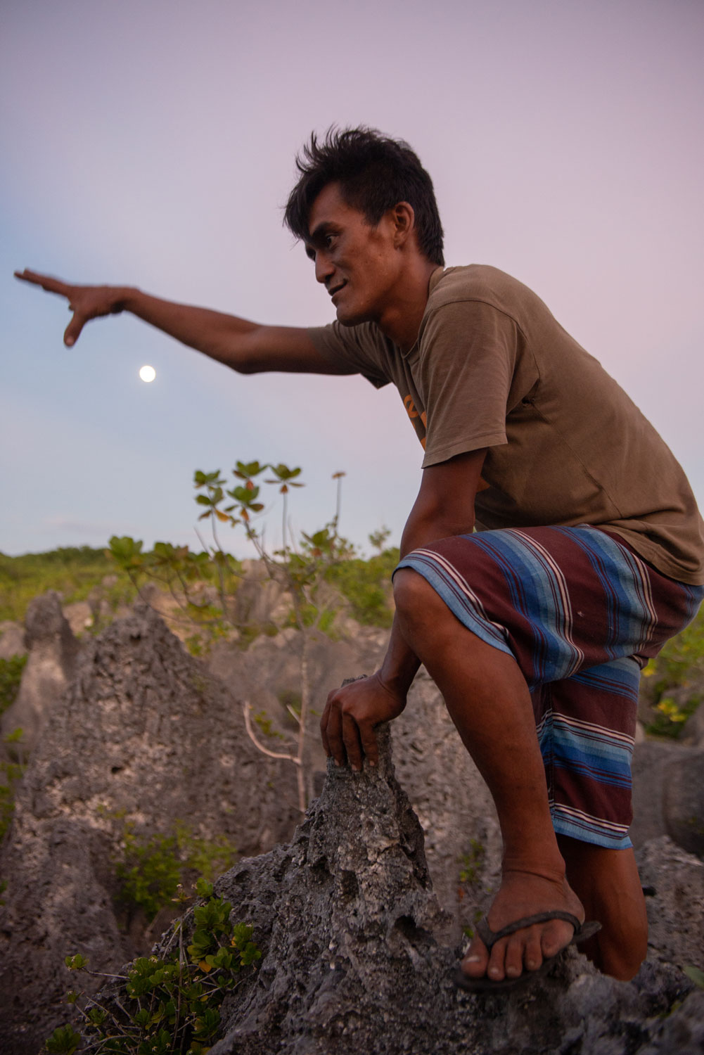
Guth and I are following Ah-scha to see the extraction zone for ourselves. Locals like him are used to this terrain. Some call those young and fit enough to travel through it les enfants des trous (the children of the holes), and despite the danger, serious accidents are rare. I, on the other hand, only last 20 minutes. As the rock gets narrower and the holes deeper, my fear takes over. If I fall, I could die. The men continue on while I find a scrap of shade under another pandanus tree and wait. My left leg dangles into one of the holes, but even when I lean over, I cannot see the bottom.
Makatea is 80 kilometers away from its closest neighbor in the Tuamotus, a group of low-lying coral atolls. It has no airport and is only accessible by supply ship (which comes about once a month from Tahiti) or by a speedboat called a poti marara, which I chartered to make the four-hour trip from the neighboring island of Rangiroa.
Until about two million years ago, Makatea looked much like the other Tuamotus—a ring of coral with a stunning turquoise lagoon. Then, Tahiti and Moorea in the Society Islands, which are 245 kilometers to the southwest, began to form. The weight of those volcanic islands depressed the seafloor and created a bulge that lifted Makatea straight out of the water. Over the past two million years and concurrent with the uplift, erosion slowly shaped the coast into an almost continuous band of sedimentary cliffs averaging 40 to 75 meters in height. On approach by boat, Makatea seems to sit on the ocean like one layer of a wedding cake. The top is quite level (though full of holes), and the sides are straight and white.
Makatea’s coastline is an almost continuous band of sedimentary rock that reaches 40 to 75 meters in height.
When we arrive at the island, a few days before meeting Ah-scha, our boat passes the concrete footing for an old crane that loaded phosphate onto ships and pulls up to the landing at Temao, Makatea’s only port. Julien Mai, Makatea’s mayor, has come to greet us. He has a round belly and wears shorts, mirrored sunglasses, and no shirt. Walking with a crutch to help with a bad leg, he shows us to his truck, and we head off down the island’s one main road, built during the mining era.
Makatea’s story has many layers, and they hit me in successive waves. Starting at Temao and heading from west to east, we drive up a steep hill to the top of the plateau. We pass a mix of forest and industrial ruins, where the large, rusted machines of an old repair shop stand like sculptures in a garden. Soon we reach the ruins of the old company town. It would have buzzed with activity when the island’s population was just over 3,000 in the 1960s. Today, glossy vines climb the walls of the old butcher shop, both inside and out. We find the old laundry, the remains of a brick oven used to bake bread, and the curved metal railing of a small bistro. Driving on, we see how the ruins of the old town blend into the modern one, where most people live today—it has the mayor’s office, a small primary school for 14 students, family homes, two churches, and a cell tower. On the far side of the village, we reach the extraction zone. The road runs parallel to that for a couple of kilometers—with holes stretching out around it—before ending on the far side of the island at a beach area called Moumu.
Mai, a proponent of the new mining proposal, was born on the island in 1952, spent many years in Japan and Guam producing Polynesian cultural shows, and has been mayor since 1995. He tells us that it’s hard to make a decent living on Makatea these days. Some people have moved back to the island as retirees with pensions, and a few can work for the municipality or the school. Others, especially those raising families, are entrepreneurs trying to make ends meet. Mai describes some of their options: there is a small tourism industry, including some rooms to rent, a rock-climbing enterprise, and day tours for occasional visits by small cruise ships. We also see evidence of agricultural initiatives along the road: bee hives, vanilla plants, and dried coconut, which can be sold for its oil. These days, the island’s biggest export is the coconut crab—Birgus latro—the world’s largest land invertebrate, which is wild caught in the forest and sold to buyers in Tahiti as a delicacy. They are worth about US $10 each and can be used as currency at the local store.
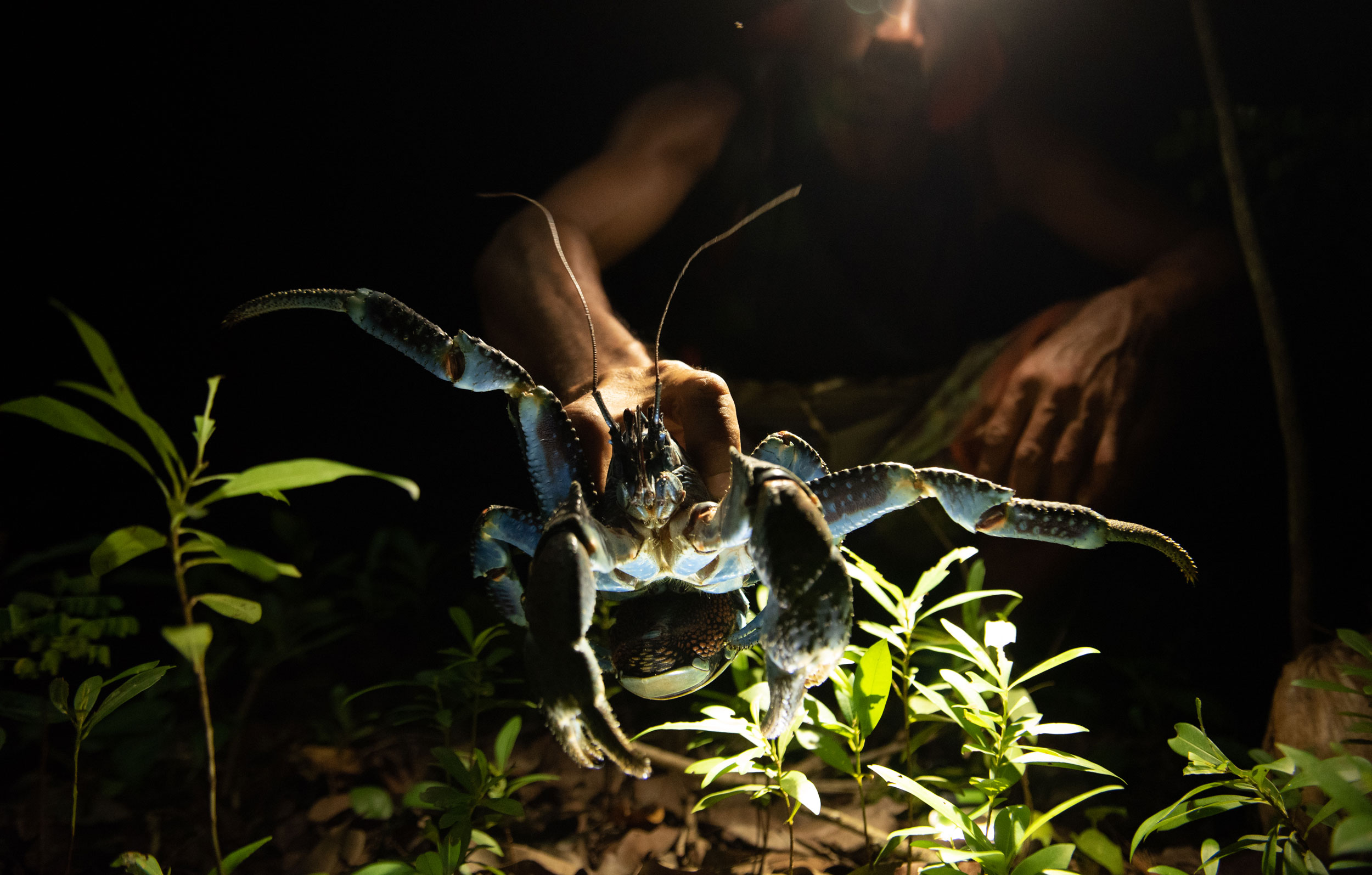
Coconut crabs are a delicacy and an important export for Makatea. Hunters must be careful handling them as these animals move quickly and have pincer strength that exceeds the biting force of most land predators.
Some of the best crab habitat can only be reached by leaving the road and crossing the extraction zone on foot. Only Ah-scha and a few others take the risk, with the added challenge of navigating by headlamp at night, because the crabs are nocturnal. Coconut crabs have pincer strength that exceeds the biting force of most land predators, so they can easily break fingers if hunters don’t quickly immobilize them with twine. Though crabs are important to Makatea’s economy, there has never been a population census here, and they have already been extirpated from many islands across their range, which extends from Pitcairn Island in the east to Seychelles in the west. Though history has shown that phosphate can support more families than commercial crabbing, it has also shown the impact of a boom and bust mining industry. At least crabs, if managed properly, are renewable. Once phosphate is gone, it’s gone.
The prevailing explanation for Makatea’s phosphate deposits dates to long before the island was uplifted. For 50 million years, Makatea existed as a low, flat-topped reef platform, dotted with shallow-water ponds that were most likely home to thick mats of cyanobacteria. These still exist today in some neighboring atolls, and local people call them kopara. The bacteria sequester phosphate from the seawater, and over millions of years, billions of generations of bacteria lived, died, and left their phosphate behind to accumulate in the relatively calm water of the ponds. Once the island was lifted, rainfall began to erode its limestones (which formed from corals and hard-shelled animals). This eventually created a karst landscape filigreed with holes and caves. Geologists estimate that 150 to 200 meters from the top of the island have already washed away completely, dissolving like sugar over hundreds of thousands of years. But phosphate is virtually insoluble in fresh water, so as the rest of the island’s surface material flowed away, the phosphate sands and rock nodules kept slipping downward, filling up cracks and holes in the landscape beneath. When miners came, all they had to do was shovel it out.
Though phosphate was first found on Makatea around 1860, the commercial enterprise did not take shape until 1906 with Britain’s Pacific Phosphate Company, which soon formed a joint venture with French and then German interests. The resulting company, La Compagnie Française des Phosphates de l’Océanie (CFPO), began extraction in 1911. Phosphate is a key ingredient for fertilizers, munitions, and pharmaceuticals, and global demand began to rise in the 19th century with the growth of modern agriculture. Over 55 years, Makatea’s phosphate was exported first to Japan and later to Australia and New Zealand.
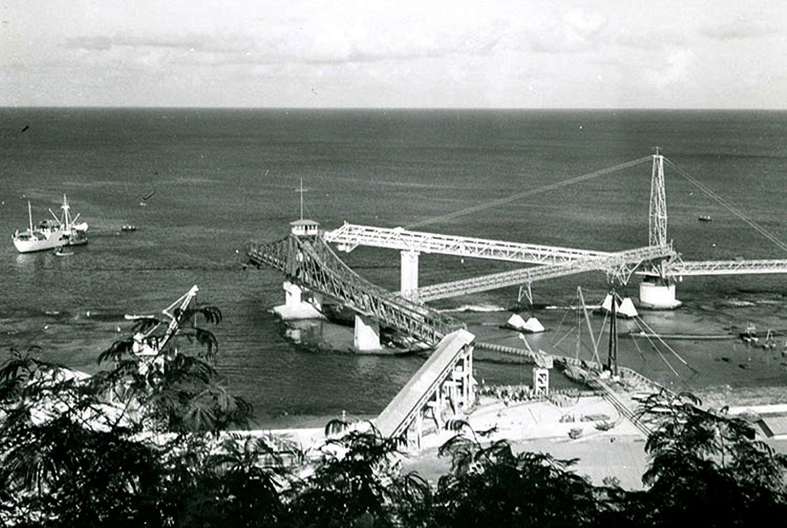

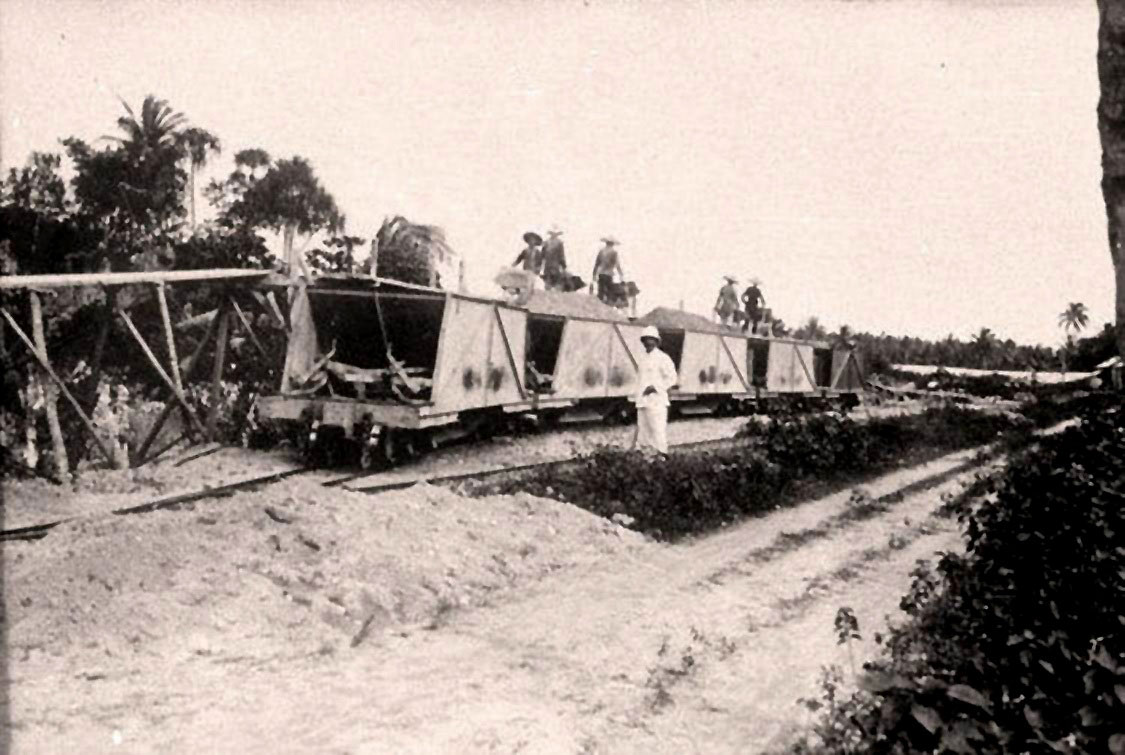
Workers loaded phosphate onto ships at Temao, Makatea’s only port, until 1966. Today, remnants of the infrastructure can still be found at the site. Photos by Louis Molet/Tahiti Heritage (historical) and Eric Guth (modern)
Prior to the mining era, Makatea was home to about 250 people, many of whom lived at Moumu. They used both land and sea to support a subsistence lifestyle. Once the mining era began, few of them worked directly for the CFPO. Instead, labor came from around the world, including indentured workers from Japan, and later from China and Vietnam. In the 1930s, the CFPO began recruiting from other parts of the South Pacific.
French authorities recognized Makateans as owners of their land, though that label had little meaning. When the CFPO cleared an area, the landowners got one franc for every tonne of phosphate shipped away. Mai says they also got one franc for every coconut palm and two francs for each breadfruit tree.
In the extraction zone, miners worked with nothing but shovels, wheelbarrows, and buckets. One man, lowered into the hole, filled buckets with sand, and his teammates hauled them up and wheeled them away. To extend their reach into the extraction zone, the men built ramps out of wooden boards. At first, the company moved phosphate from the site of extraction down to the port using a rail system and small locomotives. Later, they built an elaborate conveyor belt that spanned almost half of the island. Over the years, there were labor disputes about conditions and wages, and some survivors allege that rock dust caused grave illness and death, though there are no official records.
At the same time, the CFPO’s company town boasted electricity, running water, and even tennis courts. Louela Vairaaroa was born here in 1941. Her parents were from Makatea and her father worked for the company as a ship’s carpenter. The company paid for their housing, electricity, and medicine. They played billiards and soccer, and the island’s dance troupe won prizes against other islands. At 18 years old, Vairaaroa started work at the CFPO’s office and stayed for 10 years. No other island in the region had this kind of infrastructure, but, “It was normal for us,” says Vairaaroa, when I join her in the shade of her son’s garden.
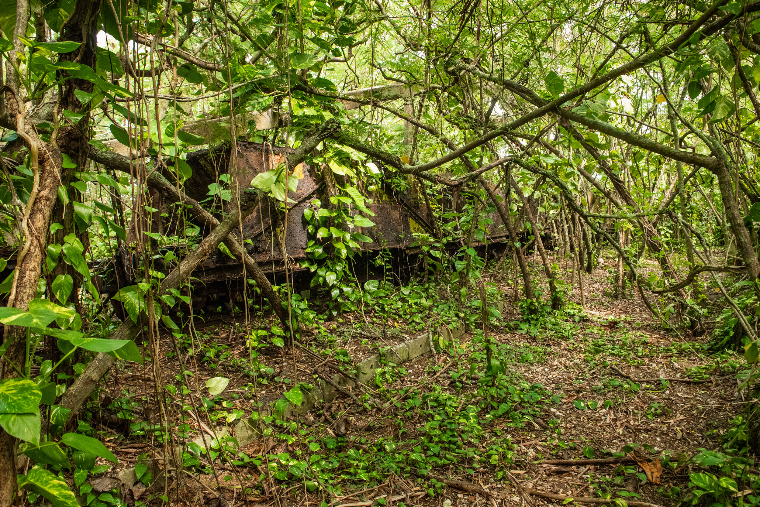
In the early days of mining, small locomotives moved phosphate from the extraction zone to the port, but were abandoned once a new conveyor belt system was implemented. Photos by Tahiti Heritage (historical) and Eric Guth (modern)
As the phosphate reserves dwindled, the mine closed abruptly at the end of 1966. Within a few months, the island’s population dropped to less than 100. France, the region’s ruling colonial government, needed skilled workers—including Vairaaroa—for the country’s now infamous nuclear testing site on Mururoa atoll. It was only when she came back to live on Makatea as a retiree that Vairaaroa really saw what they had done.
“We pitied our island. We had ruined her,” she says. “It’s so sad when you see this. It squeezes at your heart.”
We sit and admire the vegetables growing around us, fertilized with phosphate-rich sand, and I ask her about the future and the possibility of more mining.
“We don’t want this again,” she says. “Our island has already suffered so much. Certainly we can do other things.”
In 2014, Australian company SAS Avenir Makatea received an exclusive research permit to develop a new phosphate mining project. In 2016, the company applied for a mining concession, which triggered a government review of French Polynesia’s entire mining code. The project has remained in limbo ever since—neither approved nor rejected. The deadline for an official decision keeps getting extended, so no work has begun, and the campaign to prevent the mine is ongoing.
SAS Avenir Makatea’s plan is to work within the old extraction zone, removing the small amount of remaining phosphate sand, as well as a thin layer within the rock itself. To achieve this, miners would need to break the rock down, something the CFPO never did, effectively lowering the area by several meters. In theory, the resulting gravel could then fill some of those notorious holes. The proponents call it rehabilitation; the opponents call it a disaster.
The new development would mean building roads, a new port, and an airstrip, making the island more accessible. It would require heavy machinery and would kick up plenty of dust. It would also create jobs, though it’s unclear who they would go to. And it’s hard to imagine how ecotourism, which both sides support, could coexist with so much industrial activity on such a small island. Mai, the mayor, believes the risk is worth it, and that filling some of the holes is an important symbol of healing as well as a practical way to level the land and then rebuild its soil.
Mining removed 11 million tonnes of phosphate-rich sand from Makatea’s naturally occurring limestone cylinders. When the mine closed, there was no remediation.
When I’ve had my fill of industrial plans, I visit Nordman of Fatu Fenua no Makatea. She welcomes me into her living room with a glass of cold lemonade. Instead of what’s been taken from the island, she focuses on what’s left. After almost two weeks on Makatea, I feel like I’m seeing the island again for the first time.
Makatea has an abundance of fresh water, Nordman explains, which is extremely rare in the Tuamotus’s low-lying atolls. It also has endemic birds and plants and some of the only remaining primary forest in this part of the South Pacific. Coconut crabs still seem plentiful, if smaller than they once were. The island is a treasure trove for geologists, who can study ancient corals, echinoderms, and mollusks in the uplifted rock. Also, as a high island (there are fewer than 10 uplifted atolls in the Pacific Ocean), Makatea could become a climate refuge for people on neighboring islands that are vulnerable to sea level rise. Nordman thinks the place is so special that it should be a protected area. She sees a future economy fueled by small-scale enterprise, like the tourism initiatives and agricultural projects we saw along the road, though she has no formal economic plan to back those up.
With Nordman at the lead, over 250,000 people around the world have signed a petition against the new mining project. Lucien Montaggioni, professor emeritus at Aix-Marseille University in France, has been studying Makatea’s geology since the 1980s. He says SAS Avenir Makatea’s extraction estimate of 6.5 million tonnes of phosphate is an extreme overstatement, and he agrees the island should be a designated protected area. “Destroying an exceptional island to harvest a few extra tons of phosphates would be utterly abhorrent,” he wrote to the president of French Polynesia in 2016.
The new mining code specifies a period of public comment, but the code has never been implemented, so it’s unclear how much weight public comments will carry, or how the code might differentiate between the general public (anyone who lives on Makatea or its nearby islands) and Makatea’s landowners (those who actually own land). On Makatea, as in much of French Polynesia, the only existing register of land ownership was created by the French government a century ago and has never been properly updated. The legal implications are that every person descended from the original landowners is a landowner today—that includes almost the entire Makatean diaspora across French Polynesia and around the world. In other words, though Makatea has fewer than 100 residents, it has an estimated 10,000 landowners. Over the past few years, both proponents and opponents have organized public meetings on Makatea, neighboring islands, and Tahiti to try and grow their constituency in preparation for a public consultation that could begin any day.
On our last night, Reretini Viritua invites us over for a crab supper. Her wavy hair is tied back in a low bun, and she wears a leopard-print sarong tied like a minidress. She lives in the remains of the CFPO director’s house. It used to have 17 rooms, but most of them have been lost to rot and insect damage. Viritua isn’t sure how long she can keep the house standing with no budget, a few salvaged materials, and only her own physical strength to keep the forest at bay. A homemade sign hangs on the outside wall and reads, in English, “Don’t touch the Phosphates of Makatea. Please go away.” And then, in French, “Man depends on the environment and the environment depends on man.”
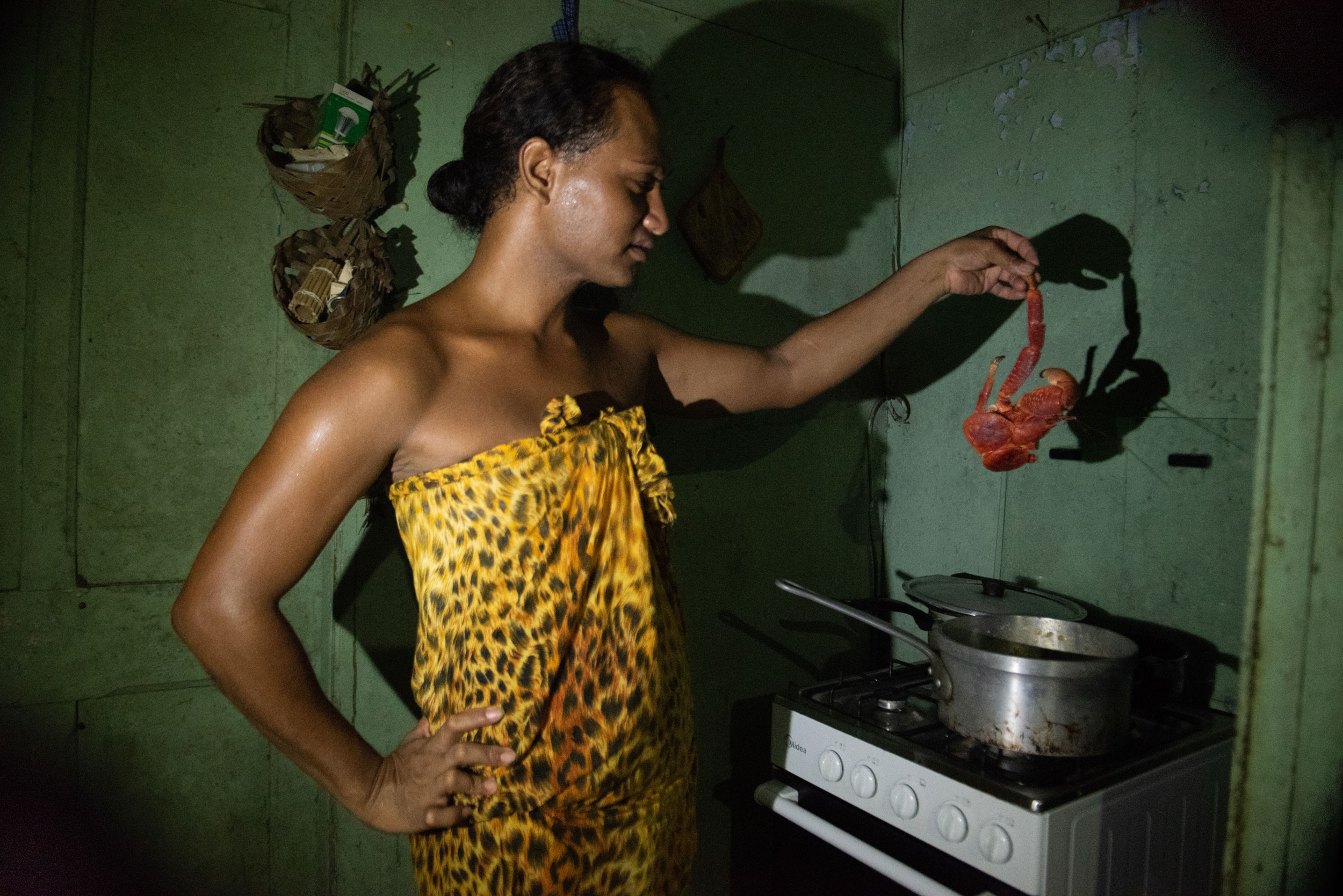
Reretini Viritua prepares a meal of coconut crab in her kitchen, within a home that once belonged to the phosphate mine’s director.
In the kitchen, with a single dangling light bulb, the cooked crabs she caught herself lie on the large central table. Their shells, usually a mix of brown and sky blue, have turned scarlet from the boiling water. We settle in our chairs, with her semiferal cats curling around our ankles, and she shows us how to crack the crabs’ thick shells with one of the limestone rocks that are so important to this island’s story.
Maybe it’s Viritua’s house that symbolizes Makatea best—it’s been shaped by a combination of history, sacrifice, and loving care, yet it’s unclear how this home will be restored.